

Skip to main contentCarte géograhique - A NEW MAP of the TERRAQUEOUS GLOBE according to the Ancient Discoveries and most general Divisions of it into CONTINENTS and OCEANS | Musée McCord Collections en ligne | Musée McCord - Musée d’histoire sociale de Montréal 


Carte géograhique
A NEW MAP of the TERRAQUEOUS GLOBE according to the Ancient Discoveries and most general Divisions of it into CONTINENTS and OCEANS
Artiste
Edward Wells
(1667-1727)
Graveur
Michael Burghers
(1650? - 1721)
Inscriptionsh.: A NEW MAP of the TERRAQUEOUS GLOBE according / to the Ancient Discoveries and most general Divisions of it into CONTINENTS and OCEANS.; cartouche: Dedicated / To his Highness / WILLIAM / Duke of Gloucester; b.g.: Delin, MBurghers sculp. Univ. Oxon.
Date
1700-1738
Médium / Technique
Encre sur papier
Taille douce colorée à la main
Taille douce colorée à la main
DimensionsHauteur : 51,5 cm (20 1/4 po)
Largeur de l'image : 50,9 cm (20 1/16 po)
Largeur : 71,5 cm (28 1/8 po)
Hauteur de l'image : 36,3 cm (14 5/16 po)
Origin
Oxford, Oxford, Angleterre, Europe
Numéro d'accession1979.194
DivisionArchives - Cartes et plans
CollectionStewart
CréditAchat
Status
Non exposéL’information sur les objets de nos collections est mise à jour afin de refléter les résultats de nouvelles recherches. Si vous avez des renseignements au sujet de cet objet à nous communiquer, veuillez faire parvenir un courriel à reference.mccord@mccord-stewart.ca.L’information au sujet des droits d’auteur et des reproductions se trouve ici.
A New Map of the most considerable plantations of the English in America
Edward Wells
1700
1979.240
A new and correct map of the world projected upon the plane of The Horizon laid down from the newest discoveries and most exact observations
Charles Price
1714
1979.196
A new and exact map of America, laid down from the latest observations & discoveries
John Bowles
1750
1979.210
The Russian Discoveries from the map publisher by the Imperial Academy of St. Petersburg.
Gerhard Friedrich Müller
1775
1970.2184
A New Chart of the Vast Atlantic Ocean Exhibiting the Seat of War both in Europe and America
Emanuel Bowen
1755
1970.2181
Mappe-Monde. Geo-Hydrographique ou Description Générale du Globe Terrestre et Aquatique en Deux Plans Hemispheres où sont exactement remarquées en Général Toutes les Parties de la Terre et de l'Eau suivant les Relations les plus nouvelles.
Nicolas Sanson
1695
1985.26
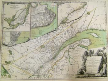
A New Map of the Province of Quebec, according to the Royal Proclamation of the 7th of October 1763
Capt. Jonathan Carver
1776
1970.2008.1-2
A new and exact map of the Dominions of the King of Great Britain on ye continent of North America...
Herman Moll
1715
1979.587
Mappe-Monde ou Carte générale du Globe Terrestre Représentée en deux Plan-Hémisphères
Nicolas Sanson
1678
1979.191
L'Hydrographie ou Description de l'Eau c'est à dire des Mers, Golfes, Lacs, Destroits, et Rivières principales, qui sont dans la Surface du Globe Terrestre
Nicolas Sanson
1652
1979.189
Mappe-Monde ou Carte Générale du Globe Terrestre Représentée en deux Plan-Hémisphères
Nicolas Sanson
1669
1979.192
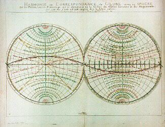
Harmonie, ou Correspondance du Globe auecq la Sphère par les Points, lignes, cercles
Nicolas Sanson
1679
1979.193
Ce projet est rendu possible grâce au généreux soutien de la Fondation Azrieli et de Patrimoine canadien.