

Skip to main contentCarte géographique - The Russian Discoveries from the map publisher by the Imperial Academy of St. Petersburg. | Musée McCord 
Collections en ligne | Musée McCord - Musée d’histoire sociale de Montréal 


Carte géographique
The Russian Discoveries from the map publisher by the Imperial Academy of St. Petersburg.
Artiste
Gerhard Friedrich Müller
(1705-1783)
Éditeur
Robert Sayer & John Bennett
(1748-1794)
Inscriptionscartouche, c.: The / Russian Discoveries, / from the map / published / by the Imperial Academy of St. Petersburg. / London Printed for Robt. Sayer, Map & Printseller, No. 53 in Fleet Street. / Published as the Act directs March 2d 1775.
Date
1775
Médium / Technique
Encre sur papier
Taille douce colorée à la main
Taille douce colorée à la main
DimensionsHauteur : 47,2 cm (18 9/16 po)
Largeur de l'image : 59,8 cm (23 9/16 po)
Largeur : 64,4 cm (25 3/8 po)
Hauteur de l'image : 43,5 cm (17 1/8 po)
Origin
London, Londres, Grand Londres, Angleterre, Europe
Numéro d'accession1970.2184
DivisionArchives - Cartes et plans
CollectionStewart
Status
Non exposéL’information sur les objets de nos collections est mise à jour afin de refléter les résultats de nouvelles recherches. Si vous avez des renseignements au sujet de cet objet à nous communiquer, veuillez faire parvenir un courriel à reference.mccord@mccord-stewart.ca.L’information au sujet des droits d’auteur et des reproductions se trouve ici.
A new and exact map of America, laid down from the latest observations & discoveries
John Bowles
1750
1979.210
A new and correct map of the world projected upon the plane of The Horizon laid down from the newest discoveries and most exact observations
Charles Price
1714
1979.196
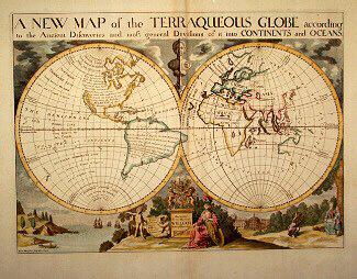
A NEW MAP of the TERRAQUEOUS GLOBE according to the Ancient Discoveries and most general Divisions of it into CONTINENTS and OCEANS
Edward Wells
1700-1738
1979.194
A map of Royal Island or Cape Breton / The Town and Harbour of Louisbourg on the Island of Cape Breton
Jacques Nicolas Bellin
1758
1979.235
A new and exact map of the Dominions of the King of Great Britain on ye continent of North America...
Herman Moll
1715
1979.587
Ce projet est rendu possible grâce au généreux soutien de la Fondation Azrieli et de Patrimoine canadien.