

Skip to main contentMap - A NEW MAP of the TERRAQUEOUS GLOBE according to the Ancient Discoveries and most general Divisions of it into CONTINENTS and OCEANS | McCord Museum Online Collections | McCord Museum - Montreal Social History Museum 


Map
A NEW MAP of the TERRAQUEOUS GLOBE according to the Ancient Discoveries and most general Divisions of it into CONTINENTS and OCEANS
Artist
Edward Wells
(1667-1727)
Engraver
Michael Burghers
(1650? - 1721)
Inscriptionsh.: A NEW MAP of the TERRAQUEOUS GLOBE according / to the Ancient Discoveries and most general Divisions of it into CONTINENTS and OCEANS.; cartouche: Dedicated / To his Highness / WILLIAM / Duke of Gloucester; b.g.: Delin, MBurghers sculp. Univ. Oxon.
Date
1700-1738
Medium / Technique
Ink on paper
Intaglio, hand-coloured
Intaglio, hand-coloured
DimensionsHeight: 51.5 cm (20 1/4 in.)
Image width: 50.9 cm (20 1/16 in.)
Width: 71.5 cm (28 1/8 in.)
Image height: 36.3 cm (14 5/16 in.)
ClassificationTools & Equipment for Science & Technology - Surveying & Navigational T&E - Navigational Equipment
Origin
Oxford, England, Europe
Object Number1979.194
DivisionArchives - Maps and Plans
CollectionStewart
CreditPurchase
Status
Not on viewInformation about the objects in our collection is updated to reflect new research findings. If you have any information to share regarding this object, please email reference.mccord@mccord-stewart.ca.Information about rights and reproductions is available here.
A New Map of the most considerable plantations of the English in America
Edward Wells
1700
1979.240
A new and correct map of the world projected upon the plane of The Horizon laid down from the newest discoveries and most exact observations
Charles Price
1714
1979.196
The Russian Discoveries from the map publisher by the Imperial Academy of St. Petersburg.
Gerhard Friedrich Müller
1775
1970.2184
A new and exact map of America, laid down from the latest observations & discoveries
John Bowles
1750
1979.210
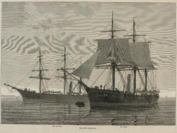
The Arctic Expedition. "The Discovery," "The Alert"
R. A. Wells
1875/05/22
M993X.5.1357
A new and exact map of the Dominions of the King of Great Britain on ye continent of North America...
Herman Moll
1715
1979.587
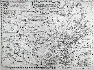
Carte d'une partie de l'Amérique Septentrionale Pour servir a l'Intelligence du Mémoire sur les Prétentions des Anglois au sujet des Limites à règler avec le France dans cette Partie du Monde; A map exhibiting a view of the English rights, relative to the ancient limits of Acadia, as supported by Express & incontestable authorities, in opposition to that of ye French
Thomas Jefferys
1768
1979.249
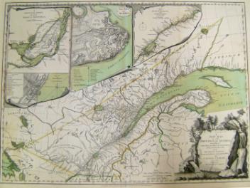
A New Map of the Province of Quebec, according to the Royal Proclamation of the 7th of October 1763
Capt. Jonathan Carver
1776
1970.2008.1-2
Mappe-Monde. Geo-Hydrographique ou Description Générale du Globe Terrestre et Aquatique en Deux Plans Hemispheres où sont exactement remarquées en Général Toutes les Parties de la Terre et de l'Eau suivant les Relations les plus nouvelles.
Nicolas Sanson
1695
1985.26
L'Amérique ou le Nouveau Continent dressée sur les Mémoires les plus nouveaux et sur les Relations les plus récentes, rectifiez sur les dernières Observations.
Jean Baptiste Nolin
1742
1983.379
Carte Nouvelle de l'Amérique Angloise contenant tout ce que les Anglois possedent sur le continent de l'Amérique Septentrionale savoir le Canada, la nouvelle Ecosse ou Acadie
Matthaus Albrecht Lotter
1778
1980.537.1
This project is made possible thanks to the generous support of the Azrieli Foundation and Canadian Heritage.