

Skip to main contentMap - Sectional Map Indicating Main Automobile Roads between Canada & United States | McCord Museum Online Collections | McCord Museum - Montreal Social History Museum 


Map
Sectional Map Indicating Main Automobile Roads between Canada & United States
Date
1929
DimensionsHeight: 102 cm (40 3/16 in.)
Width: 83 cm (32 11/16 in.)
ClassificationTools & Equipment for Science & Technology - Surveying & Navigational T&E - Navigational Equipment
Origin
Amérique du Nord
Object NumberW.2012.38.1-3
DivisionArchives - Maps and Plans
CollectionStewart
Information about the objects in our collection is updated to reflect new research findings. If you have any information to share regarding this object, please email reference.mccord@mccord-stewart.ca.Information about rights and reproductions is available here.
Principal seats of the war of 1812-13-14 To accompany Williard's History of the United States.
Samuel Maverick
1982.110.2
A new map of England and Wales in which the Roads or High-ways ar playnly layd forth...
Robert Walton
1679
1980.529
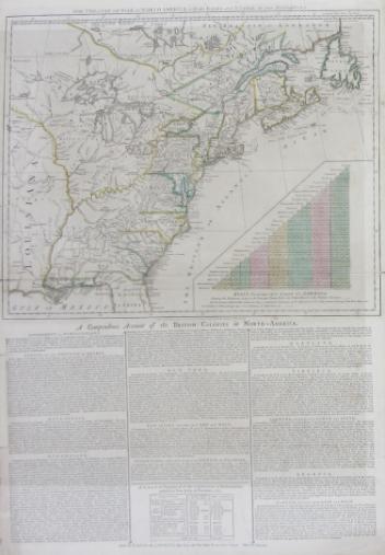
The theatre of war in North America, with the roads and a table of the distance.
Robert Sayer & John Bennett
1776
1970.1901
This project is made possible thanks to the generous support of the Azrieli Foundation and Canadian Heritage.