

Skip to main contentMap - A new map of England and Wales in which the Roads or High-ways ar playnly layd forth... | McCord Museum 
Online Collections | McCord Museum - Montreal Social History Museum 


Map
A new map of England and Wales in which the Roads or High-ways ar playnly layd forth...
Artist
Robert Walton
(1618 - 1688)
Inscriptionscartouche : A new map of / England / and Wales / in Which the Roads or highways are playnly / layd forth by two small lines from towne / too towne by which any may playnly see / the way from One place to an / other throughout / the Kingdome; cartouche b. d.: Printed colloured and sould / by Rob Walton at the Globe and / Compasse at y west end of St / Pauls church turning to Ludgate
Date
1679
Medium / Technique
Ink on paper
Intaglio
Intaglio
DimensionsHeight: 44.2 cm (17 3/8 in.)
Image width: 49.3 cm (19 7/16 in.)
Width: 56.2 cm (22 1/8 in.)
Image height: 38.2 cm (15 1/16 in.)
ClassificationTools & Equipment for Science & Technology - Surveying & Navigational T&E - Navigational Equipment
Origin
London, Greater London, England, Europe
Object Number1980.529
DivisionArchives - Maps and Plans
CollectionStewart
Status
Not on viewInformation about the objects in our collection is updated to reflect new research findings. If you have any information to share regarding this object, please email reference.mccord@mccord-stewart.ca.Information about rights and reproductions is available here.
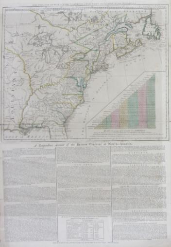
The theatre of war in North America, with the roads and a table of the distance.
Robert Sayer & John Bennett
1776
1970.1901
A New map of the North Parts of America claimed by France under ye names of Louisiana, Mississipi, Canada and New France with ye adjoyning territories of England and Spain
Herman Moll
1720
1979.250
A new chart of the coast of New England, Nova Scotia, New France or Canada with the islands of Newfoundl'd Cape Breton St John & C
Jacques Nicolas Bellin
1763
1979.298
A new chart of the coast of New England, Nova Scotia, New France or Canada with the islands of Newfoundland, Cape Breton, St. John's
Jacques Nicolas Bellin
1763
1980.510
A New Map of the most considerable plantations of the English in America
Edward Wells
1700
1979.240
A new and exact map of the Dominions of the King of Great Britain on ye continent of North America...
Herman Moll
1715
1979.587
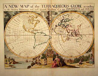
A NEW MAP of the TERRAQUEOUS GLOBE according to the Ancient Discoveries and most general Divisions of it into CONTINENTS and OCEANS
Edward Wells
1700-1738
1979.194
This project is made possible thanks to the generous support of the Azrieli Foundation and Canadian Heritage.