

Skip to main contentMap - A new map of the Province of Lower Canada | McCord Museum Online Collections | McCord Museum - Montreal Social History Museum 


Map
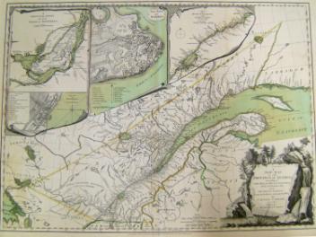
A new map of the Province of Lower Canada
Cartographer
James Wyld
(1812-1887)
InscriptionsA new map of the Province of Lower Canada, describing all the Seigneries, Townships, Grants of Land, &c. compiled from plans deposited in the Patent Office Quebec; by Samuel Holland , Esq. Surveyor General. To which is added. A Plan of the rivers, Scoudiac and Magaguadavic, Surveyed in 1796, 97, and 98, by Order of the Commissioners, appointed to ascertain the true River St. Croix intended by the Treaty of Peace in 1783 between His Britannic Majesty and United States of America. London, Published by James Wyld... 1840 - 2nd edition.
Date
1840
Medium / Technique
Ink on paper
Intaglio, hand-coloured
Intaglio, hand-coloured
DimensionsHeight: 62 cm (24 7/16 in.)
Width: 95 cm (37 3/8 in.)
ClassificationTools & Equipment for Science & Technology - Surveying & Navigational T&E - Navigational Equipment
Origin
London, Greater London, England, Europe
Object Number1970.3131
DivisionArchives - Maps and Plans
CollectionStewart
Status
Not on viewInformation about the objects in our collection is updated to reflect new research findings. If you have any information to share regarding this object, please email reference.mccord@mccord-stewart.ca.Information about rights and reproductions is available here.
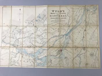
Wyld's sketch of the Country around Montreal shewing the Villages and Military Positions
James Wyld
1837
1970.1834
The Provinces of New York and New Jersey; with part of Pensilvania, and the Governments of Trois Rivieres, and Montreal
Major Samuel Holland
1775
1981.783.1
A New map of the North Parts of America claimed by France under ye names of Louisiana, Mississipi, Canada and New France with ye adjoyning territories of England and Spain
Herman Moll
1720
1979.250
A New Map of the Province of Quebec, according to the Royal Proclamation of the 7th of October 1763
Capt. Jonathan Carver
1776
1970.2008.1-2
A new and exact map of the Dominions of the King of Great Britain on ye continent of North America...
Herman Moll
1715
1979.587
A new and exact map of America, laid down from the latest observations & discoveries
John Bowles
1750
1979.210
This project is made possible thanks to the generous support of the Azrieli Foundation and Canadian Heritage.