

Skip to main contentMap - A map of the Province of Upper Canada | McCord Museum Online Collections | McCord Museum - Montreal Social History Museum 


![Carte de la Province de Poitou [...] des Provinces voisines](/internal/media/dispatcher/261414/thumbnail)


Map
A map of the Province of Upper Canada
Cartographer
James Wyld
(1812-1887)
Marks or LabelsA map of the Province of Upper Canada describing all the new settlements, townships, &c. with the countries adjacent, from Quebec to Lake Huron, compiled from the Original Geographer to her Majesty Charing Cross East 1838
Date
1838
Medium / Technique
Ink on paper
Intaglio, hand-coloured
Intaglio, hand-coloured
DimensionsHeight: 60.2 cm (23 11/16 in.)
Image width: 13 cm (5 1/8 in.)
Width: 90.8 cm (35 3/4 in.)
Image height: 20.3 cm (8 in.)
ClassificationTools & Equipment for Science & Technology - Surveying & Navigational T&E - Navigational Equipment
Origin
London, Greater London, England, Europe
Object Number1970.3130
DivisionArchives - Maps and Plans
CollectionStewart
Status
Not on viewInformation about the objects in our collection is updated to reflect new research findings. If you have any information to share regarding this object, please email reference.mccord@mccord-stewart.ca.Information about rights and reproductions is available here.
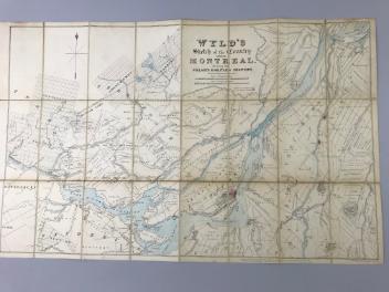
Wyld's sketch of the Country around Montreal shewing the Villages and Military Positions
James Wyld
1837
1970.1834
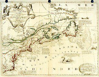
Partie orientale du Canada ou de la Nouvelle-Franceou sont les Provinces ou Pays du Saguenay, Canada, Acadie, etc., les Peuples ou Nations des Etèchemins, Iroquois, Attiquameches, etc.
Jean Baptiste Nolin
1689
1987.55
L'Europe divisée dans ses principaux états subdivisés en leurs principales provinces
Guillaume Danet
1730
1982.151.3
The Provinces of New York and New Jersey; with part of Pensilvania, and the Governments of Trois Rivieres, and Montreal
Major Samuel Holland
1775
1981.783.1
This project is made possible thanks to the generous support of the Azrieli Foundation and Canadian Heritage.