

Skip to main contentCarte géographique - A Map of Chambly Basin, Fort and Village | Musée McCord 
Collections en ligne | Musée McCord - Musée d’histoire sociale de Montréal 


Carte géographique
A Map of Chambly Basin, Fort and Village
Arpenteur
S. Metcalfe
InscriptionsA map of Chamble Basin, Fort and Village on the River Sorrel, with the British and German encampment from a survey made in 1776 drawn by S. Metcalfe.
Date
1776
Médium / Technique
Aquarelle sur papier
Origin
Canada, Amérique du Nord
Numéro d'accession1970.3028
DivisionArchives - Cartes et plans
CollectionStewart
Status
Non exposéL’information sur les objets de nos collections est mise à jour afin de refléter les résultats de nouvelles recherches. Si vous avez des renseignements au sujet de cet objet à nous communiquer, veuillez faire parvenir un courriel à reference.mccord@mccord-stewart.ca.L’information au sujet des droits d’auteur et des reproductions se trouve ici.
A Map of the british and french settlements in North America
John Lodge
1755
1979.105
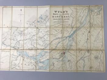
Wyld's sketch of the Country around Montreal shewing the Villages and Military Positions
James Wyld
1837
1970.1834
Amérique Septentrionale avec les routes distantes en miles, villages et établissements françois et anglois
John Mitchell
1756
1980.488
Sectional Map Indicating Main Automobile Roads between Canada & United States
1929
W.2012.38.1-3
Ce projet est rendu possible grâce au généreux soutien de la Fondation Azrieli et de Patrimoine canadien.