

Skip to main contentCarte géographique - Sectional Map Indicating Main Automobile Roads between Canada & United States | Musée McCord Collections en ligne | Musée McCord - Musée d’histoire sociale de Montréal 


Carte géographique
Sectional Map Indicating Main Automobile Roads between Canada & United States
Date
1929
DimensionsHauteur : 102 cm (40 3/16 po)
Largeur : 83 cm (32 11/16 po)
Numéro d'accessionW.2012.38.1-3
DivisionArchives - Cartes et plans
CollectionStewart
Status
Non exposéL’information sur les objets de nos collections est mise à jour afin de refléter les résultats de nouvelles recherches. Si vous avez des renseignements au sujet de cet objet à nous communiquer, veuillez faire parvenir un courriel à reference.mccord@mccord-stewart.ca.L’information au sujet des droits d’auteur et des reproductions se trouve ici.
Principal seats of the war of 1812-13-14 To accompany Williard's History of the United States.
Samuel Maverick
1982.110.2
A new map of England and Wales in which the Roads or High-ways ar playnly layd forth...
Robert Walton
1679
1980.529
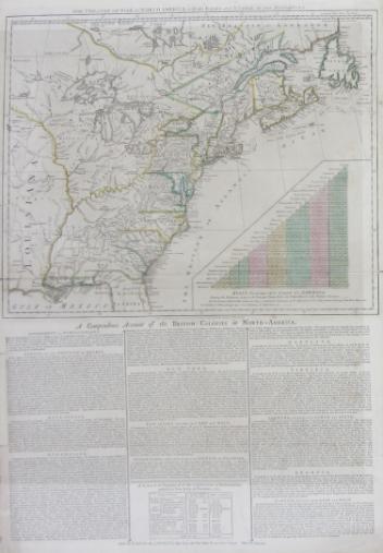
The theatre of war in North America, with the roads and a table of the distance.
Robert Sayer & John Bennett
1776
1970.1901
Ce projet est rendu possible grâce au généreux soutien de la Fondation Azrieli et de Patrimoine canadien.