

Skip to main contentCarte géographique - A new map of England and Wales in which the Roads or High-ways ar playnly layd forth... | Musée McCord 
Collections en ligne | Musée McCord - Musée d’histoire sociale de Montréal 
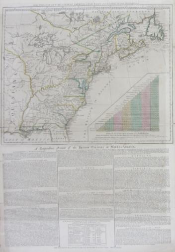


Carte géographique
A new map of England and Wales in which the Roads or High-ways ar playnly layd forth...
Artiste
Robert Walton
(1618 - 1688)
Inscriptionscartouche : A new map of / England / and Wales / in Which the Roads or highways are playnly / layd forth by two small lines from towne / too towne by which any may playnly see / the way from One place to an / other throughout / the Kingdome; cartouche b. d.: Printed colloured and sould / by Rob Walton at the Globe and / Compasse at y west end of St / Pauls church turning to Ludgate
Date
1679
Médium / Technique
Encre sur papier
Taille douce
Taille douce
DimensionsHauteur : 44,2 cm (17 3/8 po)
Largeur de l'image : 49,3 cm (19 7/16 po)
Largeur : 56,2 cm (22 1/8 po)
Hauteur de l'image : 38,2 cm (15 1/16 po)
Origin
London, Londres, Grand Londres, Angleterre, Europe
Numéro d'accession1980.529
DivisionArchives - Cartes et plans
CollectionStewart
Status
Non exposéL’information sur les objets de nos collections est mise à jour afin de refléter les résultats de nouvelles recherches. Si vous avez des renseignements au sujet de cet objet à nous communiquer, veuillez faire parvenir un courriel à reference.mccord@mccord-stewart.ca.L’information au sujet des droits d’auteur et des reproductions se trouve ici.
Sectional Map Indicating Main Automobile Roads between Canada & United States
1929
W.2012.38.1-3
The theatre of war in North America, with the roads and a table of the distance.
Robert Sayer & John Bennett
1776
1970.1901
A New map of the North Parts of America claimed by France under ye names of Louisiana, Mississipi, Canada and New France with ye adjoyning territories of England and Spain
Herman Moll
1720
1979.250
A new chart of the coast of New England, Nova Scotia, New France or Canada with the islands of Newfoundland, Cape Breton, St. John's
Jacques Nicolas Bellin
1763
1980.510
A new chart of the coast of New England, Nova Scotia, New France or Canada with the islands of Newfoundl'd Cape Breton St John & C
Jacques Nicolas Bellin
1763
1979.298
A New Map of the most considerable plantations of the English in America
Edward Wells
1700
1979.240
A new and exact map of the Dominions of the King of Great Britain on ye continent of North America...
Herman Moll
1715
1979.587
Ce projet est rendu possible grâce au généreux soutien de la Fondation Azrieli et de Patrimoine canadien.