

Skip to main contentCarte géographique - A chart of the Sea Coast of New Foundland [...] | Musée McCord Collections en ligne | Musée McCord - Musée d’histoire sociale de Montréal 


![[Sea-coasts of England]](/internal/media/dispatcher/247980/thumbnail)
![[Sea-coasts of England]](/internal/media/dispatcher/247981/thumbnail)

![A chart of the Sea Coast of New Foundland [...]](/internal/media/dispatcher/257046/mccord768watermark)
Carte géographique
A chart of the Sea Coast of New Foundland [...]
Éditeur
Mount & Page
InscriptionsA chart / of the Sea Coast of NEW FOUNDLAND / NEW SCOTLAND / NEW ENGLAND / NEW YORK / NEW JERSEY with / VIRGINIA and / MARYLAND.
Date
1735
DimensionsHauteur : 47 cm (18 1/2 po)
Largeur : 59,5 cm (23 7/16 po)
Origin
Londres, Grand Londres, Angleterre, Europe
Numéro d'accession2000.24
DivisionArchives - Cartes et plans
CollectionStewart
CréditAchat
Status
Non exposéL’information sur les objets de nos collections est mise à jour afin de refléter les résultats de nouvelles recherches. Si vous avez des renseignements au sujet de cet objet à nous communiquer, veuillez faire parvenir un courriel à reference.mccord@mccord-stewart.ca.L’information au sujet des droits d’auteur et des reproductions se trouve ici.
A chart of the Sea coast from England to the Streights
Samuel Thornton
1706
1979.290
A new chart of the coast of New England, Nova Scotia, New France or Canada with the islands of Newfoundland, Cape Breton, St. John's
Jacques Nicolas Bellin
1763
1980.510
A new chart of the coast of New England, Nova Scotia, New France or Canada with the islands of Newfoundl'd Cape Breton St John & C
Jacques Nicolas Bellin
1763
1979.298
Chart of the Atlantic Ocean, with the British, French & Spanish Settlements in North America and the West Indies; as also on the Coast of Africa
Thomas Jefferys
1768
1979.247
Chart of the Atlantic Ocean, with the British, French & Spanish Settlements in North America and the West Indies; as also on the Coast of Africa
Thomas Jefferys
1768
1979.248
Chart of the Track of the Dolphin, Tamar, Swallow & Endeavour, through the South Seas; & of the Track of M. Bougainville round the World
Louis-Antoine de Bougainville
1786
1979.186
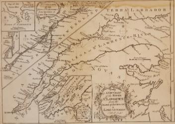
A New Chart of the River St. Lawrence from the Island of Anticosti to Lake Ontario
Thomas Kitchin
1759
1979.101
A Chart Shewing the several places of action between English and Spanish fleets...
Hubert François Gravelot
1739
1979.516
Ce projet est rendu possible grâce au généreux soutien de la Fondation Azrieli et de Patrimoine canadien.