

Skip to main contentCarte géographique - A New Chart of the River St. Lawrence from the Island of Anticosti to Lake Ontario | Musée McCord Collections en ligne | Musée McCord - Musée d’histoire sociale de Montréal 


Pas d’image disponible pour A New Chart of the River St. Lawrence from the Island of Anticosti to Lake Ontario
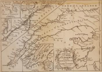
Carte géographique
A New Chart of the River St. Lawrence from the Island of Anticosti to Lake Ontario
Artiste
Thomas Kitchin
(1718-1784)
Inscriptionsh. c. : From Ft. Frederic at Crown Pt. is 84m. Water Carriage to Ft. St. John, & from thence by Fort Chambli to La Prairie opposite Montreal 19m and is made a good Road. by T. Kitchin Geor'r.
Cartouche b. c. : A new chart of the River St. Lawrence from the Island of Anticosti to Lake Ontario.
Cartouche h. g. : A continuation of the River St. Lawrence from Quebec to Lake Ontario.
Cartouche b. c. : The Traverse or Passage from Cape Torment into the South Channel of Orleans Isle. Carton h. g. : the Seven Islands, Lake Champlain.
Date
1759
Médium / Technique
Encre sur papier
Taille douce
Taille douce
DimensionsHauteur : 22 cm (8 11/16 po)
Largeur de l'image : 25,6 cm (10 1/16 po)
Largeur : 27,5 cm (10 13/16 po)
Hauteur de l'image : 18,3 cm (7 3/16 po)
Origin
London, Londres, Grand Londres, Angleterre, Europe
Numéro d'accession1979.101
DivisionArchives - Cartes et plans
CollectionStewart
Status
Non exposéL’information sur les objets de nos collections est mise à jour afin de refléter les résultats de nouvelles recherches. Si vous avez des renseignements au sujet de cet objet à nous communiquer, veuillez faire parvenir un courriel à reference.mccord@mccord-stewart.ca.
L’information au sujet des droits d’auteur et des reproductions se trouve ici.
An Exact Chart of the River St. Laurence from Fort Frontenac
Thomas Jefferys
1775
1970.3133
Government map of Canada from Red River to the Gulf of St Lawrence...
Thomas Devine
1859
1970.3030
Chart comprizing Greenland with the countries and islands about Baffin's and Hudson's Bay
Thomas Jefferys
1753
1980.511
Chart of the Atlantic Ocean, with the British, French & Spanish Settlements in North America and the West Indies; as also on the Coast of Africa
Thomas Jefferys
1768
1979.247
Chart of the Atlantic Ocean, with the British, French & Spanish Settlements in North America and the West Indies; as also on the Coast of Africa
Thomas Jefferys
1768
1979.248
A new chart of the coast of New England, Nova Scotia, New France or Canada with the islands of Newfoundl'd Cape Breton St John & C
Jacques Nicolas Bellin
1763
1979.298
A new chart of the coast of New England, Nova Scotia, New France or Canada with the islands of Newfoundland, Cape Breton, St. John's
Jacques Nicolas Bellin
1763
1980.510
Nouvelle carte de la Rivière de Canada ou St. Laurens de l'Isle de Anticosti jusqua Québec
Gerard Keulen
1723
1985.21.1
Grund Riss der Americanischen Insuln Cape Breton, St. Jean und Anticosti im Flusse S. Laurencii
Gabriel Nicolaus Raspe
1757
1979.85
Ce projet est rendu possible grâce au généreux soutien de la Fondation Azrieli et de Patrimoine canadien.