

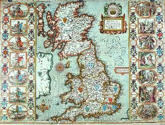
Skip to main contentCarte géographique - Europ and the chiefe cities contained therein, described; with the habits of most Kingdoms now in use | Musée McCord 
Collections en ligne | Musée McCord - Musée d’histoire sociale de Montréal 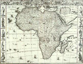


![Nova orbis tabula in lucem edita [Carte du monde]](/internal/media/dispatcher/248002/thumbnail)
Carte géographique
Europ and the chiefe cities contained therein, described; with the habits of most Kingdoms now in use
Artiste
John Speed
(1552-1629)
Graveur
Abraham Goos
(1590-1643?)
Inscriptionscartouche: EUROP, and the chiefe / Cities contained therin, descri: / bed; with the habits of most / Kingdoms now in use. / By Jo: Speed / Ano Dom. 1626
Date
1626
Médium / Technique
Encre sur papier
Gravure colorée à la main
Gravure colorée à la main
DimensionsHauteur : 44,5 cm (17 1/2 po)
Largeur de l'image : 51,3 cm (20 3/16 po)
Largeur : 57,2 cm (22 1/2 po)
Hauteur de l'image : 39,4 cm (15 1/2 po)
Origin
London, Londres, Grand Londres, Angleterre, Europe
Numéro d'accession1981.500
DivisionArchives - Cartes et plans
CollectionStewart
Status
Non exposéL’information sur les objets de nos collections est mise à jour afin de refléter les résultats de nouvelles recherches. Si vous avez des renseignements au sujet de cet objet à nous communiquer, veuillez faire parvenir un courriel à reference.mccord@mccord-stewart.ca.L’information au sujet des droits d’auteur et des reproductions se trouve ici.
Africae described, the manners of their Habits and buildings...
Abraham Goos
1626
1982.8.3
America. To Her Most Sacred Majesty Caroline, Queen of Great Britain...
Henry Overton
1740
1979.532
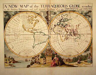
A NEW MAP of the TERRAQUEOUS GLOBE according to the Ancient Discoveries and most general Divisions of it into CONTINENTS and OCEANS
Edward Wells
1700-1738
1979.194
A new and correct map of the world projected upon the plane of The Horizon laid down from the newest discoveries and most exact observations
Charles Price
1714
1979.196
Tabula Geographico-Hydrographica Motus Oceani, Currentes, Abyssos, Montes Ignivomos in Universo Orbe Indicans
Athanasius Kircher
1680
1979.500
Ce projet est rendu possible grâce au généreux soutien de la Fondation Azrieli et de Patrimoine canadien.