

Skip to main contentCarte géographique - America. To Her Most Sacred Majesty Caroline, Queen of Great Britain... | Musée McCord Collections en ligne | Musée McCord - Musée d’histoire sociale de Montréal 


Pas d’image disponible pour America. To Her Most Sacred Majesty Caroline, Queen of Great Britain...
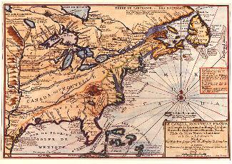
Carte géographique
America. To Her Most Sacred Majesty Caroline, Queen of Great Britain...
Artiste
Henry Overton
(1676-1751)
Graveur
Théodore de Bry
(1528-1598)
InscriptionsAmerica. To Her Most Sacred Majesty Caroline, Queen of Great Britain, France and Ireland
Date
1740
Médium / Technique
Encre sur papier
Taille douce colorée à la main
Taille douce colorée à la main
DimensionsHauteur : 57 cm (22 7/16 po)
Largeur : 96 cm (37 13/16 po)
Origin
Angleterre, Europe
Numéro d'accession1979.532
DivisionArchives - Cartes et plans
CollectionStewart
CréditAchat
Status
Non exposéL’information sur les objets de nos collections est mise à jour afin de refléter les résultats de nouvelles recherches. Si vous avez des renseignements au sujet de cet objet à nous communiquer, veuillez faire parvenir un courriel à reference.mccord@mccord-stewart.ca.L’information au sujet des droits d’auteur et des reproductions se trouve ici.
A new and exact map of the Dominions of the King of Great Britain on ye continent of North America...
Herman Moll
1715
1979.587
Le Canada, ou Nouvelle France, la Floride, la Virginie, Pensilvanie, Caroline, Nouvelle Angleterre et Nouvelle Yorck, l'Isle de Terre Neuve, la Louisiane et le cours de la Rivière de Misisipi
Nicolas de Fer
1702
1982.408
A New Map of the most considerable plantations of the English in America
Edward Wells
1700
1979.240
La America Dispuesta segun las ultimas, y nuevas observationes de las Accademias, y de Paris y de Londres
1740
1979.208
America Settentrionale Colle Nuove Scoperte fin all'Anno 1688
Vincenzo Maria Coronelli
1696
1979.504.1-2
Chart of the Atlantic Ocean, with the British, French & Spanish Settlements in North America and the West Indies; as also on the Coast of Africa
Thomas Jefferys
1768
1979.247
Chart of the Atlantic Ocean, with the British, French & Spanish Settlements in North America and the West Indies; as also on the Coast of Africa
Thomas Jefferys
1768
1979.248
Ce projet est rendu possible grâce au généreux soutien de la Fondation Azrieli et de Patrimoine canadien.