

Skip to main contentMap - Government map of Canada from Red River to the Gulf of St Lawrence... | McCord Museum 
Online Collections | McCord Museum - Montreal Social History Museum 

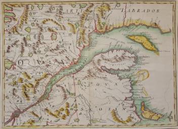


Map
Government map of Canada from Red River to the Gulf of St Lawrence...
Artist
Thomas Devine
InscriptionsGovernment map of Canada from red River to the Gulf of St.Lawrence compiled by Thomas Devine...Head of Surveys Upper Canada Branch Crown Lands Department November 1859. includes table of the counties in upper & in llower Canada: list of the Railways Stations with distances from principal city to given stations and the distance between stations. A very general description of Canada in terms of laws taxes, roads, schools, etc..: a list of some natural resources including principal kinds of timber. Roads, canals, colonization roads are marked on map.
Date
1859
Medium / Technique
Coloured ink on paper
Lithography
Lithography
DimensionsHeight: 79 cm (31 1/8 in.)
Width: 172 cm (67 11/16 in.)
ClassificationTools & Equipment for Science & Technology - Surveying & Navigational T&E - Navigational Equipment
Origin
Canada, North America
Object Number1970.3030
DivisionArchives - Maps and Plans
CollectionStewart
CreditPurchase
Status
Not on viewInformation about the objects in our collection is updated to reflect new research findings. If you have any information to share regarding this object, please email reference.mccord@mccord-stewart.ca.Information about rights and reproductions is available here.
A New Chart of the River St. Lawrence from the Island of Anticosti to Lake Ontario
Thomas Kitchin
1759
1979.101
Carte d'une partie de l'Amérique Septentrionale Pour servir a l'Intelligence du Mémoire sur les Prétentions des Anglois au sujet des Limites à règler avec le France dans cette Partie du Monde; A map exhibiting a view of the English rights, relative to the ancient limits of Acadia, as supported by Express & incontestable authorities, in opposition to that of ye French
Thomas Jefferys
1768
1979.249
Chart of the Atlantic Ocean, with the British, French & Spanish Settlements in North America and the West Indies; as also on the Coast of Africa
Thomas Jefferys
1768
1979.247
Chart of the Atlantic Ocean, with the British, French & Spanish Settlements in North America and the West Indies; as also on the Coast of Africa
Thomas Jefferys
1768
1979.248
Chart comprizing Greenland with the countries and islands about Baffin's and Hudson's Bay
Thomas Jefferys
1753
1980.511
This project is made possible thanks to the generous support of the Azrieli Foundation and Canadian Heritage.