

Skip to main contentMap - A New Chart of the River St. Lawrence from the Island of Anticosti to Lake Ontario | McCord Museum Online Collections | McCord Museum - Montreal Social History Museum 


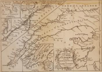


Image Not Availablefor A New Chart of the River St. Lawrence from the Island of Anticosti to Lake Ontario
Map
A New Chart of the River St. Lawrence from the Island of Anticosti to Lake Ontario
Artist
Thomas Kitchin
(1718-1784)
Inscriptionsh. c. : From Ft. Frederic at Crown Pt. is 84m. Water Carriage to Ft. St. John, & from thence by Fort Chambli to La Prairie opposite Montreal 19m and is made a good Road. by T. Kitchin Geor'r.
Cartouche b. c. : A new chart of the River St. Lawrence from the Island of Anticosti to Lake Ontario.
Cartouche h. g. : A continuation of the River St. Lawrence from Quebec to Lake Ontario.
Cartouche b. c. : The Traverse or Passage from Cape Torment into the South Channel of Orleans Isle. Carton h. g. : the Seven Islands, Lake Champlain.
Date
1759
Medium / Technique
Ink on paper
Intaglio
Intaglio
DimensionsHeight: 22 cm (8 11/16 in.)
Image width: 25.6 cm (10 1/16 in.)
Width: 27.5 cm (10 13/16 in.)
Image height: 18.3 cm (7 3/16 in.)
ClassificationTools & Equipment for Science & Technology - Surveying & Navigational T&E - Navigational Equipment
Origin
London, Greater London, England, Europe
Object Number1979.101
DivisionArchives - Maps and Plans
CollectionStewart
Status
Not on viewInformation about the objects in our collection is updated to reflect new research findings. If you have any information to share regarding this object, please email reference.mccord@mccord-stewart.ca.Information about rights and reproductions is available here.
Chart comprizing Greenland with the countries and islands about Baffin's and Hudson's Bay
Thomas Jefferys
1753
1980.511
Chart of the Atlantic Ocean, with the British, French & Spanish Settlements in North America and the West Indies; as also on the Coast of Africa
Thomas Jefferys
1768
1979.247
Chart of the Atlantic Ocean, with the British, French & Spanish Settlements in North America and the West Indies; as also on the Coast of Africa
Thomas Jefferys
1768
1979.248
Government map of Canada from Red River to the Gulf of St Lawrence...
Thomas Devine
1859
1970.3030
A new chart of the coast of New England, Nova Scotia, New France or Canada with the islands of Newfoundland, Cape Breton, St. John's
Jacques Nicolas Bellin
1763
1980.510
A new chart of the coast of New England, Nova Scotia, New France or Canada with the islands of Newfoundl'd Cape Breton St John & C
Jacques Nicolas Bellin
1763
1979.298
Carte d'une partie de l'Amérique Septentrionale Pour servir a l'Intelligence du Mémoire sur les Prétentions des Anglois au sujet des Limites à règler avec le France dans cette Partie du Monde; A map exhibiting a view of the English rights, relative to the ancient limits of Acadia, as supported by Express & incontestable authorities, in opposition to that of ye French
Thomas Jefferys
1768
1979.249
This project is made possible thanks to the generous support of the Azrieli Foundation and Canadian Heritage.