

Skip to main contentMap - Map of British Colonies of North America | McCord Museum 
Online Collections | McCord Museum - Montreal Social History Museum 


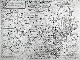


Map
Map of British Colonies of North America
Publisher
Thomas Kelly
InscriptionsBritish Colonies or North America Published by Thomas Kelly, No. 53 Paternoster Row, London.
Date
1837
Medium / Technique
Ink and watercolour on paper
Intaglio, hand-coloured
Intaglio, hand-coloured
DimensionsHeight: 21 cm (8 1/4 in.)
Image width: 25.5 cm (10 1/16 in.)
Width: 26.5 cm (10 7/16 in.)
Image height: 19 cm (7 1/2 in.)
ClassificationTools & Equipment for Science & Technology - Surveying & Navigational T&E - Navigational Equipment
Origin
London, Greater London, England, Europe
Object Number1978.1964
DivisionArchives - Maps and Plans
CollectionStewart
CreditPurchase
Status
Not on viewInformation about the objects in our collection is updated to reflect new research findings. If you have any information to share regarding this object, please email reference.mccord@mccord-stewart.ca.Information about rights and reproductions is available here.
Chart of the Atlantic Ocean, with the British, French & Spanish Settlements in North America and the West Indies; as also on the Coast of Africa
Thomas Jefferys
1768
1979.247
Chart of the Atlantic Ocean, with the British, French & Spanish Settlements in North America and the West Indies; as also on the Coast of Africa
Thomas Jefferys
1768
1979.248
Carte d'une partie de l'Amérique Septentrionale Pour servir a l'Intelligence du Mémoire sur les Prétentions des Anglois au sujet des Limites à règler avec le France dans cette Partie du Monde; A map exhibiting a view of the English rights, relative to the ancient limits of Acadia, as supported by Express & incontestable authorities, in opposition to that of ye French
Thomas Jefferys
1768
1979.249
Government map of Canada from Red River to the Gulf of St Lawrence...
Thomas Devine
1859
1970.3030
An accurate map of the British Empire in North America as settled by Preliminaries in 1762
John Gibson
1762
1979.104
This project is made possible thanks to the generous support of the Azrieli Foundation and Canadian Heritage.