

Skip to main contentMap - An Exact Chart of the River St. Laurence from Fort Frontenac | McCord Museum Online Collections | McCord Museum - Montreal Social History Museum 


Map
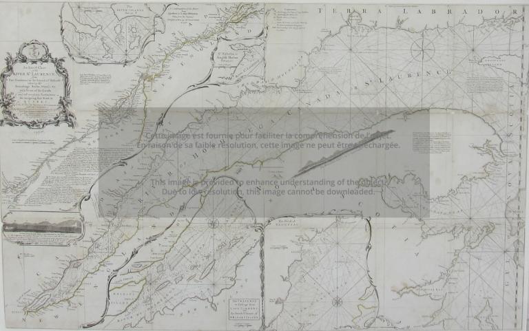
An Exact Chart of the River St. Laurence from Fort Frontenac
Artist
Thomas Jefferys
(about 1719 - 1771)
InscriptionsAn exact chart of the River St. Lawrence, from Fort Frontenac to the Island of Anticosti shewing the Soundings, Rocks, Shoals et c with views of the lands and all necessary instructions for navigating the River to Quebec...(1775). (Imprint lacking) Top right section (19.5 X 13.5) missing. (map scale English and French leagues).
Date
1775
Medium / Technique
Ink on paper
Intaglio
Intaglio
DimensionsHeight: 59.5 cm (23 7/16 in.)
Width: 95.7 cm (37 11/16 in.)
ClassificationTools & Equipment for Science & Technology - Surveying & Navigational T&E - Navigational Equipment
Origin
Europe
Object Number1970.3133
DivisionArchives - Maps and Plans
CollectionStewart
Information about the objects in our collection is updated to reflect new research findings. If you have any information to share regarding this object, please email reference.mccord@mccord-stewart.ca.Information about rights and reproductions is available here.
Chart of the Atlantic Ocean, with the British, French & Spanish Settlements in North America and the West Indies; as also on the Coast of Africa
Thomas Jefferys
1768
1979.247
Chart of the Atlantic Ocean, with the British, French & Spanish Settlements in North America and the West Indies; as also on the Coast of Africa
Thomas Jefferys
1768
1979.248
Chart comprizing Greenland with the countries and islands about Baffin's and Hudson's Bay
Thomas Jefferys
1753
1980.511
Carte d'une partie de l'Amérique Septentrionale Pour servir a l'Intelligence du Mémoire sur les Prétentions des Anglois au sujet des Limites à règler avec le France dans cette Partie du Monde; A map exhibiting a view of the English rights, relative to the ancient limits of Acadia, as supported by Express & incontestable authorities, in opposition to that of ye French
Thomas Jefferys
1768
1979.249
A New Chart of the River St. Lawrence from the Island of Anticosti to Lake Ontario
Thomas Kitchin
1759
1979.101
A plan of the Town and Fort of Carillon at Ticonderoga; with the Attack made by the British Army.
Thomas Jefferys
1759
1970.2070
Government map of Canada from Red River to the Gulf of St Lawrence...
Thomas Devine
1859
1970.3030
A correct plan of the environs of Quebec, and of the battle fought on the 13th September, 1759
Thomas Jefferys
1759
1992.103
A large and particular plan of Shegnekto Bay, and the circumjacent country...
Thomas Jefferys
1755
1983.371
A Correct Plan of the Environs of Quebec and the Battle fought on 13th September 1759
Thomas Jefferys
1759
2003.1
This project is made possible thanks to the generous support of the Azrieli Foundation and Canadian Heritage.