

Skip to main contentMap - Richelieu River | McCord Museum Online Collections | McCord Museum - Montreal Social History Museum 


Map
Richelieu River
InscriptionsRichelieu river. Chambly Basin to Lake Champlain (Canada, Quebec). Surveyed by Mr. R.J. Frases and N. Wilson, 1922. Shoreline & sounding in the Richelieu River from Dept. of Public Works... Polyconic Prolection; soundings in feet; map scale (and other relevant data) Published by the Canadian Hydrographic Service. Surveys and Mapping Branch Dep't. of Mines & Technical Surveys, Ottawa. New Edition, May 30, 1951 (#1326)
Date
1951
Medium / Technique
Ink on paper
Chromolithography
Chromolithography
DimensionsHeight: 102 cm (40 3/16 in.)
Image width: 30.1 cm (11 7/8 in.)
Width: 53.8 cm (21 3/16 in.)
Image height: 95.7 cm (37 11/16 in.)
ClassificationTools & Equipment for Science & Technology - Surveying & Navigational T&E - Navigational Equipment
Origin
Ottawa, Ontario, Canada, North America
Object Number1970.303
DivisionArchives - Maps and Plans
CollectionStewart
Information about the objects in our collection is updated to reflect new research findings. If you have any information to share regarding this object, please email reference.mccord@mccord-stewart.ca.Information about rights and reproductions is available here.
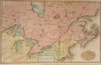
Government map of Canada from Red River to the Gulf of St Lawrence...
Thomas Devine
1859
1970.3030
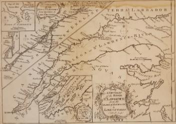
A New Chart of the River St. Lawrence from the Island of Anticosti to Lake Ontario
Thomas Kitchin
1759
1979.101
North America - River St. Lawrence above Quebec Sheet XIII Long Point to Lachine Rapids including Montreal
1860
1995.126
This project is made possible thanks to the generous support of the Azrieli Foundation and Canadian Heritage.