

Skip to main contentCarte géographique - A new map of the Province of Lower Canada | Musée McCord Collections en ligne | Musée McCord - Musée d’histoire sociale de Montréal 


Carte géographique
A new map of the Province of Lower Canada
Cartographe
James Wyld
(1812-1887)
InscriptionsA new map of the Province of Lower Canada, describing all the Seigneries, Townships, Grants of Land, &c. compiled from plans deposited in the Patent Office Quebec; by Samuel Holland , Esq. Surveyor General. To which is added. A Plan of the rivers, Scoudiac and Magaguadavic, Surveyed in 1796, 97, and 98, by Order of the Commissioners, appointed to ascertain the true River St. Croix intended by the Treaty of Peace in 1783 between His Britannic Majesty and United States of America. London, Published by James Wyld... 1840 - 2nd edition.
Date
1840
Médium / Technique
Encre sur papier
Taille douce colorée à la main
Taille douce colorée à la main
DimensionsHauteur : 62 cm (24 7/16 po)
Largeur : 95 cm (37 3/8 po)
Origin
London, Londres, Grand Londres, Angleterre, Europe
Numéro d'accession1970.3131
DivisionArchives - Cartes et plans
CollectionStewart
Status
Non exposéL’information sur les objets de nos collections est mise à jour afin de refléter les résultats de nouvelles recherches. Si vous avez des renseignements au sujet de cet objet à nous communiquer, veuillez faire parvenir un courriel à reference.mccord@mccord-stewart.ca.
L’information au sujet des droits d’auteur et des reproductions se trouve ici.
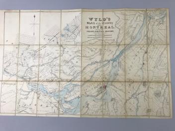
Wyld's sketch of the Country around Montreal shewing the Villages and Military Positions
James Wyld
1837
1970.1834
A new and exact map of the Dominions of the King of Great Britain on ye continent of North America...
Herman Moll
1715
1979.587
A new and exact map of America, laid down from the latest observations & discoveries
John Bowles
1750
1979.210
The Provinces of New York and New Jersey; with part of Pensilvania, and the Governments of Trois Rivieres, and Montreal
Major Samuel Holland
1775
1981.783.1
Ce projet est rendu possible grâce au généreux soutien de la Fondation Azrieli et de Patrimoine canadien.