

Skip to main contentCarte géographique - A map of the Province of Upper Canada | Musée McCord Collections en ligne | Musée McCord - Musée d’histoire sociale de Montréal 


![Carte de la Province de Poitou [...] des Provinces voisines](/internal/media/dispatcher/261414/thumbnail)


Carte géographique
A map of the Province of Upper Canada
Cartographe
James Wyld
(1812-1887)
MarquesA map of the Province of Upper Canada describing all the new settlements, townships, &c. with the countries adjacent, from Quebec to Lake Huron, compiled from the Original Geographer to her Majesty Charing Cross East 1838
Date
1838
Médium / Technique
Encre sur papier
Taille douce colorée à la main
Taille douce colorée à la main
DimensionsHauteur : 60,2 cm (23 11/16 po)
Largeur de l'image : 13 cm (5 1/8 po)
Largeur : 90,8 cm (35 3/4 po)
Hauteur de l'image : 20,3 cm (8 po)
Origin
London, Londres, Grand Londres, Angleterre, Europe
Numéro d'accession1970.3130
DivisionArchives - Cartes et plans
CollectionStewart
Status
Non exposéL’information sur les objets de nos collections est mise à jour afin de refléter les résultats de nouvelles recherches. Si vous avez des renseignements au sujet de cet objet à nous communiquer, veuillez faire parvenir un courriel à reference.mccord@mccord-stewart.ca.L’information au sujet des droits d’auteur et des reproductions se trouve ici.
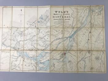
Wyld's sketch of the Country around Montreal shewing the Villages and Military Positions
James Wyld
1837
1970.1834
Carte de la Province de Poitou [...] des Provinces voisines
Jean Crépy
1767
1983.730
L'Europe divisée dans ses principaux états subdivisés en leurs principales provinces
Guillaume Danet
1730
1982.151.3
The Provinces of New York and New Jersey; with part of Pensilvania, and the Governments of Trois Rivieres, and Montreal
Major Samuel Holland
1775
1981.783.1
Carte de la France divisée par les provinces de l'esglise Galicane...
Jean Boisseau
1642
1981.503
L'Europe divisée suivant l'estendüe de ses principaux Estats subdivisés en leurs principales Provinces.
Nicolas Sanson
1695
1985.25
A map of Royal Island or Cape Breton / The Town and Harbour of Louisbourg on the Island of Cape Breton
Jacques Nicolas Bellin
1758
1979.235
Ce projet est rendu possible grâce au généreux soutien de la Fondation Azrieli et de Patrimoine canadien.