

Skip to main contentPlan - Plan of the Town & Fortifications of Montreal or Ville Marie in Canada | Musée McCord 
Collections en ligne | Musée McCord - Musée d’histoire sociale de Montréal ![A Plan of the City & Fortifications of Louisburg [...] 1745. A Plan of the City and Harbour of Louisburg [...] 1745](/internal/media/dispatcher/260844/thumbnail)


Plan
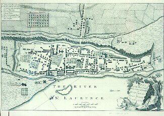
Plan of the Town & Fortifications of Montreal or Ville Marie in Canada
Inscriptionslégende : p. 504
References to the annexed fine PLAN and VIEW of MONTREAL in CANADA, (see p. 543.)
To the PLAN.
A. A dry ditch about eight feet deep - B. The town wall, the parapet of which is only about four feet thick, of masonry - C. Marquis de Vaudreuil, the governor general's palace - D. Monsieur de Longueuil's house - E. The fort, only a cavalier, without a parapet.
To the VIEW.
1. The river St. Laurence - 2. St. Peter's river - 3. A bridge over St. Peter's river - 4. M. de Calliere's house - 5. The general hospital - 6. A dry ditch encompassing the town - 7. The Glacis - 8. The small gate - 9. The market gate - 10. St. Mary's gate - 11. Water gate - 12. The Sally-port - 13. The Recollet's convent - 14. The parish church - 15. The nunnery hospital - 16. The Jesuit's church and seminary - 17. The palace of M. de Vaudreuil - 18. M. de Longueuil's house - 19. The citadel - 20. The wharf.
From succint view of the importance of Canada, (1800 miles in length, and 1260 in breadth) it appears, that there are in it 120 out parishes, and about 150 armed men in each parish, one with another; which amount
to 18,000
In Quebec ---- 700
Trois Rivieres ---- 350
Montreal ---- 600
Total 19,650
Date
1760
Médium / Technique
Encre sur papier
Lithographie
Lithographie
DimensionsHauteur : 17 cm (6 11/16 po)
Largeur : 25 cm (9 13/16 po)
Origin
Angleterre, Europe
Numéro d'accession1970.2004
DivisionArchives - Cartes et plans
CollectionStewart
Status
Non exposéL’information sur les objets de nos collections est mise à jour afin de refléter les résultats de nouvelles recherches. Si vous avez des renseignements au sujet de cet objet à nous communiquer, veuillez faire parvenir un courriel à reference.mccord@mccord-stewart.ca.L’information au sujet des droits d’auteur et des reproductions se trouve ici.
A Plan of the City & Fortifications of Louisburg [...] 1745. A Plan of the City and Harbour of Louisburg [...] 1745
John Hinton
1758
1979.165
Plan du Port et Ville de Louisbourg, dans l'Isle Royale. Plan de la Ville de Québec. Plan of the Town of Halifax in Nova Scotia. 1756.
Homann Erben
1756
1979.522
A plan of the Town and Fort of Carillon at Ticonderoga; with the Attack made by the British Army.
Thomas Jefferys
1759
1970.2070
A Plan of the Town and Harbour of Louisbourg in the Island of Cape Breton
Emanuel Bowen
1747
1979.166
Plan provisoire du canal de Lachine du pied du courant Sainte-Marie jusqu'à son embranchement vers le port de Montréal
Alexander Gibbs
Avant 1821
P195/A9.1
Plan des Villes de Londres et de Westminster et de leurs Faubourgs avec le Bourg de Southwark
Charles Inselin
1705
1979.175
Ce projet est rendu possible grâce au généreux soutien de la Fondation Azrieli et de Patrimoine canadien.