

Skip to main contentCarte géographique - [Map of Lower and Upper Canada] | Musée McCord Collections en ligne | Musée McCord - Musée d’histoire sociale de Montréal 


Pas d’image disponible pour [Map of Lower and Upper Canada]
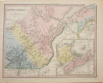
Carte géographique
[Map of Lower and Upper Canada]
Cartographe
William Faden
(1749-1836)
Éditeur
J. Walker & Sons
Dessinateur
Joseph Bouchette
(1774-1841)
InscriptionsTo His Royal Highness George Augustus Frederick, Prince of Wales, Duke of Cornwall, &c. &c. &c. and Prince Regent of the United Kingdom of Great Britain & Ireland; This Topographical Map of the Province of Lower Canada, Shewing its division into Districts, Counties, Seigniories & Townships, with all the Lands reserved both for the Crown & the Clergy, &c. Is With His Royal Highness's Special Permission, most gratefully Dedicated by a faithful & zealous Canadian Subject, and His Royal Highness's Most Obedient & Devoted Servant, Joseph Bouchette, His Majesty's Surveyor General of the Province & Lieutenant Colonel C.M.
Date
1815
Médium / Technique
Papier
DimensionsHauteur : 35 cm (13 3/4 po)
Largeur : 36 cm (14 3/16 po)
Origin
London, Londres, Grand Londres, Angleterre, Europe
Numéro d'accession1983.91.1-10
DivisionArchives - Cartes et plans
CollectionStewart
CréditAchat
Status
Non exposéL’information sur les objets de nos collections est mise à jour afin de refléter les résultats de nouvelles recherches. Si vous avez des renseignements au sujet de cet objet à nous communiquer, veuillez faire parvenir un courriel à reference.mccord@mccord-stewart.ca.L’information au sujet des droits d’auteur et des reproductions se trouve ici.
Sectional Map Indicating Main Automobile Roads between Canada & United States
1929
W.2012.38.1-3
A Map of the Present Seat of War on the Borders of Canada.
Robert Aitken
1775
1970.3027
Government map of Canada from Red River to the Gulf of St Lawrence...
Thomas Devine
1859
1970.3030
Ce projet est rendu possible grâce au généreux soutien de la Fondation Azrieli et de Patrimoine canadien.