

Skip to main contentCarte géographique - The Magdalen Islands in the Gulph of St. Lawrence... | Musée McCord 
Collections en ligne | Musée McCord - Musée d’histoire sociale de Montréal 


![Carte de la Rivière Longue et de quelque autres qui se déchargent dans le grand fleuve de Mississipi [...] les portage d'un lieu à l'autre](/internal/media/dispatcher/260692/thumbnail)


Carte géographique
The Magdalen Islands in the Gulph of St. Lawrence...
Artiste
Joseph Frederick Wallet des Barres
(1722-1824)
InscriptionsThe Magdalen Islands in the Gulph of St. Lawrence Published according to Act of Parliament Sep'r the 1st 1781 by J.F.W. Des Barres Esq. (from Atlantic Neptune). one of the twenty restrickes printed by Daniel Potvin, Ottawa, from an original Des Barres copper plate held by Eleventh International conference on the History of Cartography, Ottawa, 8-12 July 1985.
Date
1781
Médium / Technique
Encre sur papier
Taille douce
Taille douce
DimensionsHauteur : 75,7 cm (29 13/16 po)
Largeur de l'image : 53,9 cm (21 1/4 po)
Largeur : 56,5 cm (22 1/4 po)
Hauteur de l'image : 73 cm (28 3/4 po)
Origin
London, Londres, Grand Londres, Angleterre, Europe
Numéro d'accession1985.42
DivisionArchives - Cartes et plans
CollectionStewart
Status
Non exposéL’information sur les objets de nos collections est mise à jour afin de refléter les résultats de nouvelles recherches. Si vous avez des renseignements au sujet de cet objet à nous communiquer, veuillez faire parvenir un courriel à reference.mccord@mccord-stewart.ca.L’information au sujet des droits d’auteur et des reproductions se trouve ici.
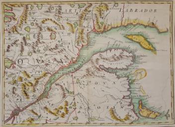
A new chart of the coast of New England, Nova Scotia, New France or Canada with the islands of Newfoundland, Cape Breton, St. John's
Jacques Nicolas Bellin
1763
1980.510
A new chart of the coast of New England, Nova Scotia, New France or Canada with the islands of Newfoundl'd Cape Breton St John & C
Jacques Nicolas Bellin
1763
1979.298
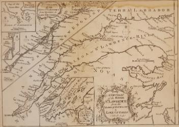
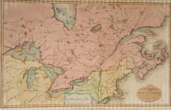
A New Chart of the River St. Lawrence from the Island of Anticosti to Lake Ontario
Thomas Kitchin
1759
1979.101
Poli Arctici et circumiacentium terrarum descriptio novissima
Frederick de Wit
1675
1979.264
La Grande Rivière de Canada Appelée par les Européens de St. Laurens
Jean de Deshayes
Vers 1685
1979.232
Carte particulière des environs de St. Malo et des entrées de la Rivière de Dinan, comme elles paroissent aux plus basses marées
Nicolas de Fer
1690
1980.452
Carte de la Rivière Longue et de quelque autres qui se déchargent dans le grand fleuve de Mississipi [...] les portage d'un lieu à l'autre
Baron Louis-Armand de Lom d'Arce de Lahontan
1715
1979.100
Carte de la Rivière Longue et quelques autres qui se déchargent dans le grand fleuve de Mississipi
Baron Louis-Armand de Lom d'Arce de Lahontan
1705
1979.83
Chart comprizing Greenland with the countries and islands about Baffin's and Hudson's Bay
Thomas Jefferys
1753
1980.511
Ce projet est rendu possible grâce au généreux soutien de la Fondation Azrieli et de Patrimoine canadien.