

Skip to main contentCarte géographique - A Correct Drawing of the North Pole and of all the countries... | Musée McCord 
Collections en ligne | Musée McCord - Musée d’histoire sociale de Montréal 


Carte géographique
A Correct Drawing of the North Pole and of all the countries...
Géographe
Emanuel Bowen
(1694-1767)
Inscriptionsh. d.: Vol. II page 377; cartouche : A / correct draught / of the / North Pole / and of all the Countries / hitherto Discovered, intercepted / between the Pole and the Parallel / of 50 Degrees. Exhibiting the / Most Remarkable Tracts of our / English Navigators / in their several attempts to find / out the North East and North West / Passages. Drawn from the most / approv'd modern Maps and / Charts, and adjusted by / Astronl Observations / by Eman: Bowen / Geographer to His Majesty.
Date
1752
Médium / Technique
Encre sur papier
Taille douce
Taille douce
DimensionsHauteur : 41,2 cm (16 1/4 po)
Largeur de l'image : 44,2 cm (17 3/8 po)
Largeur : 49,7 cm (19 9/16 po)
Hauteur de l'image : 39 cm (15 3/8 po)
Origin
London, Londres, Grand Londres, Angleterre, Europe
Numéro d'accession1979.267
DivisionArchives - Cartes et plans
CollectionStewart
Status
Non exposéL’information sur les objets de nos collections est mise à jour afin de refléter les résultats de nouvelles recherches. Si vous avez des renseignements au sujet de cet objet à nous communiquer, veuillez faire parvenir un courriel à reference.mccord@mccord-stewart.ca.L’information au sujet des droits d’auteur et des reproductions se trouve ici.
A New Chart of the Vast Atlantic Ocean Exhibiting the Seat of War both in Europe and America
Emanuel Bowen
1755
1970.2181
Chart comprizing Greenland with the countries and islands about Baffin's and Hudson's Bay
Thomas Jefferys
1753
1980.511
A Map of the British and French Settlements in North America
Thomas Bowen
1755
1983.46.12-13
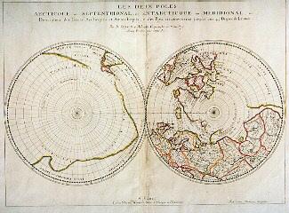
Les deux poles arctique ou septentrional, et antarctique ou meridional, ou description des poles arctiques et antarctique, et des pays circomvoisins jusques aux 45 degrés de latitude
Nicolas Sanson
1657
1979.260
A newe discription of the whole worlde in twoe Hemispheres shewing the twoe Poles of the Worlde /.../
Jean Boisseau
1645
1979.501
A new and correct map of the world projected upon the plane of The Horizon laid down from the newest discoveries and most exact observations
Charles Price
1714
1979.196
A Correct Plan of the Environs of Quebec, and of the Battle faught on the 13th September 1759
1993.10
Les deux pôles arctique ou septentrional, et Antarctique ou Méridional, ou description des terres arctiques et antarctiques, et des pays circumvoisins jusques aux 45 degres de latitude
Nicolas Sanson
1690
1979.265
The theatre of war in North America, with the roads and a table of the distance.
Robert Sayer & John Bennett
1776
1970.1901
Ce projet est rendu possible grâce au généreux soutien de la Fondation Azrieli et de Patrimoine canadien.