

Skip to main contentCarte géographique - Richelieu River | Musée McCord Collections en ligne | Musée McCord - Musée d’histoire sociale de Montréal 


Carte géographique
Richelieu River
InscriptionsRichelieu river. Chambly Basin to Lake Champlain (Canada, Quebec). Surveyed by Mr. R.J. Frases and N. Wilson, 1922. Shoreline & sounding in the Richelieu River from Dept. of Public Works... Polyconic Prolection; soundings in feet; map scale (and other relevant data) Published by the Canadian Hydrographic Service. Surveys and Mapping Branch Dep't. of Mines & Technical Surveys, Ottawa. New Edition, May 30, 1951 (#1326)
Date
1951
Médium / Technique
Encre sur papier
Chromolithographie
Chromolithographie
DimensionsHauteur : 102 cm (40 3/16 po)
Largeur de l'image : 30,1 cm (11 7/8 po)
Largeur : 53,8 cm (21 3/16 po)
Hauteur de l'image : 95,7 cm (37 11/16 po)
Origin
Ottawa, Ontario, Canada, Amérique du Nord
Numéro d'accession1970.303
DivisionArchives - Cartes et plans
CollectionStewart
L’information sur les objets de nos collections est mise à jour afin de refléter les résultats de nouvelles recherches. Si vous avez des renseignements au sujet de cet objet à nous communiquer, veuillez faire parvenir un courriel à reference.mccord@mccord-stewart.ca.L’information au sujet des droits d’auteur et des reproductions se trouve ici.
North America - River St. Lawrence above Quebec Sheet XIII Long Point to Lachine Rapids including Montreal
1860
1995.126
Government map of Canada from Red River to the Gulf of St Lawrence...
Thomas Devine
1859
1970.3030
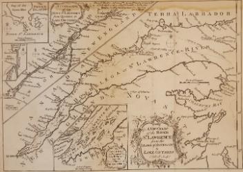
A New Chart of the River St. Lawrence from the Island of Anticosti to Lake Ontario
Thomas Kitchin
1759
1979.101
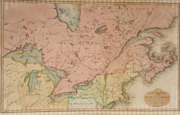
An Exact Chart of the River St. Laurence from Fort Frontenac
Thomas Jefferys
1775
1970.3133
Ce projet est rendu possible grâce au généreux soutien de la Fondation Azrieli et de Patrimoine canadien.