

Skip to main contentPlan - Plan of part of the Province of Lower Canada | McCord Museum 
Online Collections | McCord Museum - Montreal Social History Museum 
![Le Plan de Louisbourg dans L'Isle royale au Canada. 1757 [...]](/internal/media/dispatcher/260826/thumbnail)


![A Plan of the City & Fortifications of Louisburg [...] 1745. A Plan of the City and Harbour of Louisburg [...] 1745](/internal/media/dispatcher/260844/thumbnail)


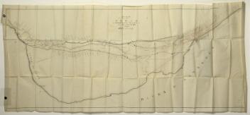


Plan
Plan of part of the Province of Lower Canada
Marks or LabelsPlan of part the province of Lower Canada containing the country from the River Montmorency near Quebec upwards as far as any surveys have been hitherto made,that is to St. Regis on the R'r. St. Lawrence, and to the Township of Buckhingham on the R'r. Ottawa, compiled in the Surveyor General's Office in the latter part of the year 1794 & early part of the year 1795 by Messrs. Samuel Gale & John B. Duberger from the undermentioned materials... (details follow)...N.B. This plan is reduced from the original wich was compiled in the Surveyor General's Office on a scale of two miles to one incl. Done in the Engineer's Drawing Room at Quebec by John B. Duberger Draftsman. By Order of his Excellency Lord Dorchester Captain General & Governor in Chief of Provinces of Upper & Lower Canada, &c., &c.
Date
1795
Medium / Technique
Ink on paper
Lithography
Lithography
DimensionsHeight: 75.5 cm (29 3/4 in.)
Image width: 150 cm (59 1/16 in.)
Width: 158.7 cm (62 1/2 in.)
Image height: 66 cm (26 in.)
Origin
London?, Greater London, England, Europe
Object Number1970.3049
DivisionArchives - Maps and Plans
CollectionStewart
Status
Not on viewInformation about the objects in our collection is updated to reflect new research findings. If you have any information to share regarding this object, please email reference.mccord@mccord-stewart.ca.
Information about rights and reproductions is available here.
Plan du Port et Ville de Louisbourg, dans l'Isle Royale. Plan de la Ville de Québec. Plan of the Town of Halifax in Nova Scotia. 1756.
Homann Erben
1756
1979.522
A Plan of the City & Fortifications of Louisburg [...] 1745. A Plan of the City and Harbour of Louisburg [...] 1745
John Hinton
1758
1979.165
City of Montreal. Parts of St. James, East, Centre, St. Louis and St. Lawrence Wards
Alphonse Rodrigue Pinsoneault
ca. 1907
RB-1494.14
Proposed Plan of the Lachine Canal from the Foot of St. Mary's Current to the Branch Leading to the Port of Montreal
Alexander Gibbs
before 1821
P195/A9.1
This project is made possible thanks to the generous support of the Azrieli Foundation and Canadian Heritage.