

Skip to main contentPlan - Plan of Oswego | McCord Museum Online Collections | McCord Museum - Montreal Social History Museum ![Le Plan de Louisbourg dans L'Isle royale au Canada. 1757 [...]](/internal/media/dispatcher/260826/thumbnail)


![A Plan of the City & Fortifications of Louisburg [...] 1745. A Plan of the City and Harbour of Louisburg [...] 1745](/internal/media/dispatcher/260844/thumbnail)


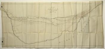

Plan
Plan of Oswego
Engineer
Gaspard Chaussegros de Léry
(1682-1756)
Inscriptionsfait à Montréal ce 17e juillet 1727 (Signé) Chaussegros de Lery
Date
1727
Medium / Technique
Ink on paper
Lithography
Lithography
DimensionsHeight: 28 cm (11 in.)
Image width: 36.9 cm (14 1/2 in.)
Width: 38.6 cm (15 3/16 in.)
Image height: 25.5 cm (10 1/16 in.)
Origin
Paris, Île-de-France, France, Europe
Object Number1970.2118
DivisionArchives - Maps and Plans
CollectionStewart
Information about the objects in our collection is updated to reflect new research findings. If you have any information to share regarding this object, please email reference.mccord@mccord-stewart.ca.Information about rights and reproductions is available here.
Plan of the Forts Ontario and Oswego, with Part of the Rivetr Onondago and Lake Ontario
1757
1979.168
Plan du Port et Ville de Louisbourg, dans l'Isle Royale. Plan de la Ville de Québec. Plan of the Town of Halifax in Nova Scotia. 1756.
Homann Erben
1756
1979.522
A Plan of the City & Fortifications of Louisburg [...] 1745. A Plan of the City and Harbour of Louisburg [...] 1745
John Hinton
1758
1979.165
St. Malo Ville de la Haute Bretagne située dans L'isle St. Aaron. Carte particulière des environs de St. Malo et des entrées de la Rivière de Dinan comme elles paroissent aux plus Basses Marées.
Antoine de Fer
1652
1979.293
Attaques du Fort William-Henri en Amérique par les troupes française aux ordres du Marquis de Montcalm. Prise de ce fort le 7 août 1757.
Laurids de Therbu
1793
1970.2072
Attaques des Forts de Chouaguen en Amérique pris par les Français commandés par le Marquis de Montcalm. Le 14 Août 1756.
Laurids de Therbu
1792
1970.2073
Attaques des Forts de Chouaguen en Amérique pris. par les français commandés par le marquis de Montcalm le 14 Aout 1756
Laurids de Therbu
1792
1979.159
Proposed Plan of the Lachine Canal from the Foot of St. Mary's Current to the Branch Leading to the Port of Montreal
Alexander Gibbs
before 1821
P195/A9.1
This project is made possible thanks to the generous support of the Azrieli Foundation and Canadian Heritage.