

Skip to main contentMap - Map of Canada West in Counties | McCord Museum Online Collections | McCord Museum - Montreal Social History Museum 


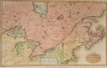


Map
Map of Canada West in Counties
Publisher
Samuel Augustus Mitchell Jr.
? (1826 - 1882)
Publisher
Samuel Augustus Mitchell Sr.
? (1792 - 1868)
InscriptionsMap of Canada West in Counties. Map scale in miles. Entered according to Act of Congress in the year 1860 by S. Augustus Mitchell Jr. in the Clerks Office of the District Court of the U.S. for the Eastern District of Pennsylvania.
Date
1865
Medium / Technique
Ink on paper
Intaglio
Intaglio
DimensionsHeight: 30.2 cm (11 7/8 in.)
Image width: 33.8 cm (13 5/16 in.)
Width: 37.9 cm (14 15/16 in.)
Image height: 27 cm (10 5/8 in.)
ClassificationTools & Equipment for Science & Technology - Surveying & Navigational T&E - Navigational Equipment
Origin
Philadelphia, Pennsylvania, United States, North America
Object Number1970.1909
DivisionArchives - Maps and Plans
CollectionStewart
Information about the objects in our collection is updated to reflect new research findings. If you have any information to share regarding this object, please email reference.mccord@mccord-stewart.ca.Information about rights and reproductions is available here.
Amérique Septentrionale avec les routes distantes en miles, villages et établissements françois et anglois
John Mitchell
1756
1980.488
This project is made possible thanks to the generous support of the Azrieli Foundation and Canadian Heritage.