

Skip to main contentMap - Map of Gulf of St. Lawrence | McCord Museum Online Collections | McCord Museum - Montreal Social History Museum 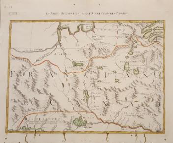


![La vera descritione di tutta la Francia et la Spagna et la Fiandra [France, Espagne]](/internal/media/dispatcher/260872/thumbnail)


Map
Map of Gulf of St. Lawrence
Artist
Antonio Zatta
(1722-1804)
InscriptionsNuova Scozia Parte di Labrador
Date
1778
Medium / Technique
Ink on paper
Intaglio
Intaglio
DimensionsHeight: 31.9 cm (12 9/16 in.)
Image width: 42.2 cm (16 5/8 in.)
Width: 43.5 cm (17 1/8 in.)
Image height: 30.5 cm (12 in.)
ClassificationTools & Equipment for Science & Technology - Surveying & Navigational T&E - Navigational Equipment
Origin
Venice, Veneto, Italy, Europe
Object Number1970.1903
DivisionArchives - Maps and Plans
CollectionStewart
Information about the objects in our collection is updated to reflect new research findings. If you have any information to share regarding this object, please email reference.mccord@mccord-stewart.ca.Information about rights and reproductions is available here.
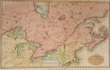
Government map of Canada from Red River to the Gulf of St Lawrence...
Thomas Devine
1859
1970.3030
La vera descritione di tutta la Francia et la Spagna et la Fiandra [France, Espagne]
Antonio Lafreri
1554
1980.524
The Russian Discoveries from the map publisher by the Imperial Academy of St. Petersburg.
Gerhard Friedrich Müller
1775
1970.2184
A map of Royal Island or Cape Breton / The Town and Harbour of Louisbourg on the Island of Cape Breton
Jacques Nicolas Bellin
1758
1979.235
This project is made possible thanks to the generous support of the Azrieli Foundation and Canadian Heritage.