

Skip to main contentMap - Map of the St. Lawrence River | McCord Museum Online Collections | McCord Museum - Montreal Social History Museum 


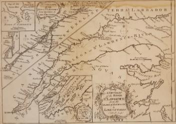


Map
Map of the St. Lawrence River
Artist
Samuel John Neele
(1758 - 1824)
Publisher
Richard Phillips
(1767-1840)
InscriptionsMap of the River St. Lawrence from its embouchure to its source to illustrate a picturesque description of the Canadas. London: Published March 1st 1807 by R. Phillips New Bridge Street. Neele Sculp. Strand.
Date
1807
Medium / Technique
Ink on paper
Intaglio
Intaglio
DimensionsHeight: 25.8 cm (10 3/16 in.)
Image width: 38.2 cm (15 1/16 in.)
Width: 43.4 cm (17 1/16 in.)
Image height: 23.6 cm (9 5/16 in.)
ClassificationTools & Equipment for Science & Technology - Surveying & Navigational T&E - Navigational Equipment
Origin
London, Greater London, England, Europe
Object Number1970.1902
DivisionArchives - Maps and Plans
CollectionStewart
Information about the objects in our collection is updated to reflect new research findings. If you have any information to share regarding this object, please email reference.mccord@mccord-stewart.ca.Information about rights and reproductions is available here.
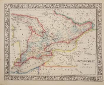
Government map of Canada from Red River to the Gulf of St Lawrence...
Thomas Devine
1859
1970.3030
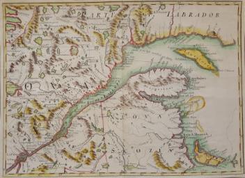
A New Chart of the River St. Lawrence from the Island of Anticosti to Lake Ontario
Thomas Kitchin
1759
1979.101
The Russian Discoveries from the map publisher by the Imperial Academy of St. Petersburg.
Gerhard Friedrich Müller
1775
1970.2184
An accurate map of the British Empire in North America as settled by Preliminaries in 1762
John Gibson
1762
1979.104
A new and exact map of America, laid down from the latest observations & discoveries
John Bowles
1750
1979.210
This project is made possible thanks to the generous support of the Azrieli Foundation and Canadian Heritage.