

Skip to main contentCarte géographique - The British Governments in North America | Musée McCord Collections en ligne | Musée McCord - Musée d’histoire sociale de Montréal 


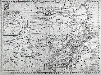


Carte géographique
The British Governments in North America
Graveur
John Gibson
(deceased 1792)
InscriptionsCartouche, h.g.: THE BRITISH / GOVERNMENTS / in / N.TH AMERICA / Laid down agreeable to the / PROCLAMATION / of / OCT.R 7,1763; cartouche, b.g.: BERMUDA / or / SUMMER ISLANDS / NTH Lat. 32.10 to Long. 47.5
MarquesJ. Gibson Sculp.
Date
1763
Médium / Technique
Encre et aquarelle sur papier
Taille douce
Taille douce
DimensionsHauteur : 22 cm (8 11/16 po)
Largeur de l'image : 23,5 cm (9 1/4 po)
Largeur : 28 cm (11 po)
Hauteur de l'image : 20,2 cm (7 15/16 po)
Origin
Londres, Grand Londres, Angleterre, Europe
Numéro d'accession1970.1894
DivisionArchives - Cartes et plans
CollectionStewart
L’information sur les objets de nos collections est mise à jour afin de refléter les résultats de nouvelles recherches. Si vous avez des renseignements au sujet de cet objet à nous communiquer, veuillez faire parvenir un courriel à reference.mccord@mccord-stewart.ca.L’information au sujet des droits d’auteur et des reproductions se trouve ici.
An accurate map of the British Empire in North America as settled by Preliminaries in 1762
John Gibson
1762
1979.104
The Provinces of New York and New Jersey; with part of Pensilvania, and the Governments of Trois Rivieres, and Montreal
Major Samuel Holland
1775
1981.783.1
A Map of the british and french settlements in North America
John Lodge
1755
1979.105
Chart of the Atlantic Ocean, with the British, French & Spanish Settlements in North America and the West Indies; as also on the Coast of Africa
Thomas Jefferys
1768
1979.247
Chart of the Atlantic Ocean, with the British, French & Spanish Settlements in North America and the West Indies; as also on the Coast of Africa
Thomas Jefferys
1768
1979.248
A Map of the British and French Settlements in North America
Thomas Bowen
1755
1983.46.12-13
A map of the British Empire in America with the French and Spanish settements adjacent thereto
Henry Popple
1733
1980.490.1
A map of the British Empire in America with the French and Spanish settements adjacent thereto
Henry Popple
1733
1980.490.21
Ce projet est rendu possible grâce au généreux soutien de la Fondation Azrieli et de Patrimoine canadien.