

Skip to main contentCarte géographique - An accurate map of the British Empire in North America as settled by Preliminaries in 1762 | Musée McCord 
Collections en ligne | Musée McCord - Musée d’histoire sociale de Montréal 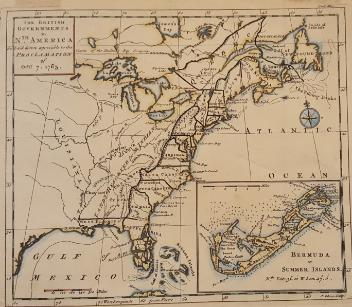


Carte géographique
An accurate map of the British Empire in North America as settled by Preliminaries in 1762
Graveur
John Gibson
(deceased 1792)
Inscriptionscartouche b. c.: An / Accurate Map / of the / BRITISH EMPIRE / in / Nth AMERICA / as settled by / the Preliminaries in / 1762; b. d.: J. Gibson sculp
Date
1762
Médium / Technique
Encre sur papier
Taille douce
Taille douce
DimensionsHauteur : 22,7 cm (8 15/16 po)
Largeur de l'image : 24,2 cm (9 1/2 po)
Largeur : 25,1 cm (9 7/8 po)
Hauteur de l'image : 20,8 cm (8 3/16 po)
Origin
London, Londres, Grand Londres, Angleterre, Europe
Numéro d'accession1979.104
DivisionArchives - Cartes et plans
CollectionStewart
CréditAchat
Status
Non exposéL’information sur les objets de nos collections est mise à jour afin de refléter les résultats de nouvelles recherches. Si vous avez des renseignements au sujet de cet objet à nous communiquer, veuillez faire parvenir un courriel à reference.mccord@mccord-stewart.ca.L’information au sujet des droits d’auteur et des reproductions se trouve ici.
A map of the British Empire in America with the French and Spanish settements adjacent thereto
Henry Popple
1733
1980.490.1
A map of the British Empire in America with the French and Spanish settements adjacent thereto
Henry Popple
1733
1980.490.21
A Map of the british and french settlements in North America
John Lodge
1755
1979.105
A map of the British Empire in America with the French and Spanish settements adjacent thereto
Henry Popple
1733
1980.490.12
A map of the British Empire in America with the French and Spanish settements adjacent thereto
Henry Popple
1733
1980.490.13
A map of the British Empire in America with the French and Spanish settements adjacent thereto
Henry Popple
1733
1980.490.10
A map of the British Empire in America with the French and Spanish settements adjacent thereto
Henry Popple
1733
1980.490.11
A map of the British Empire in America with the French and Spanish settements adjacent thereto
Henry Popple
1733
1980.490.8
Ce projet est rendu possible grâce au généreux soutien de la Fondation Azrieli et de Patrimoine canadien.