

Skip to main contentCarte géographique - A New Chart of the River St. Lawrence | Musée McCord Collections en ligne | Musée McCord - Musée d’histoire sociale de Montréal 


![A chart of the Sea Coast of New Foundland [...]](/internal/media/dispatcher/257046/thumbnail)

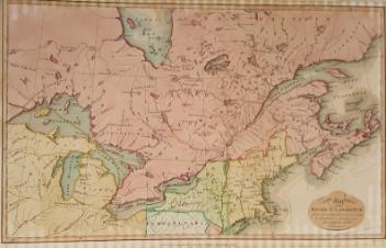
Carte géographique
A New Chart of the River St. Lawrence
Graveur
Andrew Bell
(1726-1809)
InscriptionsA New chart of the River St. Lawrence from the Island of Anticosti to Lake Ontario. A. Bell Sculp't.
Date
1764
Médium / Technique
Encre sur papier
Taille douce
Taille douce
DimensionsHauteur : 20,7 cm (8 1/8 po)
Largeur de l'image : 25,3 cm (9 15/16 po)
Largeur : 27,7 cm (10 7/8 po)
Hauteur de l'image : 17,9 cm (7 1/16 po)
Origin
Londres, Grand Londres, Angleterre, Europe
Numéro d'accession1970.1907
DivisionArchives - Cartes et plans
CollectionStewart
L’information sur les objets de nos collections est mise à jour afin de refléter les résultats de nouvelles recherches. Si vous avez des renseignements au sujet de cet objet à nous communiquer, veuillez faire parvenir un courriel à reference.mccord@mccord-stewart.ca.L’information au sujet des droits d’auteur et des reproductions se trouve ici.
A New Chart of the River St. Lawrence from the Island of Anticosti to Lake Ontario
Thomas Kitchin
1759
1979.101
A new chart of the coast of New England, Nova Scotia, New France or Canada with the islands of Newfoundland, Cape Breton, St. John's
Jacques Nicolas Bellin
1763
1980.510
A new chart of the coast of New England, Nova Scotia, New France or Canada with the islands of Newfoundl'd Cape Breton St John & C
Jacques Nicolas Bellin
1763
1979.298
An Exact Chart of the River St. Laurence from Fort Frontenac
Thomas Jefferys
1775
1970.3133
A chart of the Sea coast from England to the Streights
Samuel Thornton
1706
1979.290
A Chart Shewing the several places of action between English and Spanish fleets...
Hubert François Gravelot
1739
1979.516
Chart of the Atlantic Ocean, with the British, French & Spanish Settlements in North America and the West Indies; as also on the Coast of Africa
Thomas Jefferys
1768
1979.247
Chart of the Atlantic Ocean, with the British, French & Spanish Settlements in North America and the West Indies; as also on the Coast of Africa
Thomas Jefferys
1768
1979.248
Chart of the Track of the Dolphin, Tamar, Swallow & Endeavour, through the South Seas; & of the Track of M. Bougainville round the World
Louis-Antoine de Bougainville
1786
1979.186
Ce projet est rendu possible grâce au généreux soutien de la Fondation Azrieli et de Patrimoine canadien.