

Skip to main contentPlan - Fortifications de Montréal, 1759 | Musée McCord Collections en ligne | Musée McCord - Musée d’histoire sociale de Montréal 
![A Plan of the City & Fortifications of Louisburg [...] 1745. A Plan of the City and Harbour of Louisburg [...] 1745](/internal/media/dispatcher/260844/thumbnail)


Plan
Fortifications de Montréal, 1759
Date
1759
DimensionsHauteur : 24 cm (9 7/16 po)
Largeur : 36,5 cm (14 3/8 po)
Numéro d'accession1970.1958
DivisionArchives - Cartes et plans
CollectionStewart
L’information sur les objets de nos collections est mise à jour afin de refléter les résultats de nouvelles recherches. Si vous avez des renseignements au sujet de cet objet à nous communiquer, veuillez faire parvenir un courriel à reference.mccord@mccord-stewart.ca.L’information au sujet des droits d’auteur et des reproductions se trouve ici.
A Plan of the City & Fortifications of Louisburg [...] 1745. A Plan of the City and Harbour of Louisburg [...] 1745
John Hinton
1758
1979.165
A Correct Plan of the Environs of Quebec and the Battle fought on 13th September 1759
Thomas Jefferys
1759
2003.1
A correct plan of the environs of Quebec, and of the battle fought on the 13th September, 1759
Thomas Jefferys
1759
1992.103
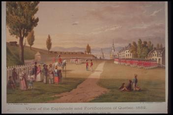
Vue de l'esplanade et des fortifications de Québec, 1832
Robert Auchmuty Sproule
1874
M17263
Vue des fortifications de Québec, Québec, 1862-1871
Smeaton's Photographic Gallery
1862-1871
M2019.7.2.95
Vue des fortifications de Québec, Québec, 1862-1871
Smeaton's Photographic Gallery
1862-1871
M2019.7.2.2.224
A Correct Plan of the Environs of Quebec, and of the Battle faught on the 13th September 1759
1993.10
Ce projet est rendu possible grâce au généreux soutien de la Fondation Azrieli et de Patrimoine canadien.