

Skip to main contentPlan - Quebec and its environs, with the operation of the siege | McCord Museum 
Online Collections | McCord Museum - Montreal Social History Museum 


Plan
Quebec and its environs, with the operation of the siege
Artist
John Lambert
(1775-1816?)
Publisher
Cradock & Joy
Inscriptionsh.g.: QUEBEC /AND ITS ENVIRONS, /with the /OPERATION of the SIEGE./ Draws from the Survey made by the Order of/ ADMIRAL SAUNDERS; b.c.: London Published Oct. 25, 1813 by Cradock & Joy, Paternoster Row
Date
1813
Medium / Technique
Ink on paper
Intaglio, hand-coloured
Intaglio, hand-coloured
DimensionsHeight: 12.7 cm (5 in.)
Image width: 16.2 cm (6 3/8 in.)
Width: 18.4 cm (7 1/4 in.)
Image height: 11 cm (4 5/16 in.)
Origin
London, Greater London, England, Europe
Object Number1970.1897
DivisionArchives - Maps and Plans
CollectionStewart
Status
Not on viewInformation about the objects in our collection is updated to reflect new research findings. If you have any information to share regarding this object, please email reference.mccord@mccord-stewart.ca.
Information about rights and reproductions is available here.
St. Malo Ville de la Haute Bretagne située dans L'isle St. Aaron. Carte particulière des environs de St. Malo et des entrées de la Rivière de Dinan comme elles paroissent aux plus Basses Marées.
Antoine de Fer
1652
1979.293
A correct plan of the environs of Quebec, and of the battle fought on the 13th September, 1759
Thomas Jefferys
1759
1992.103
A Correct Plan of the Environs of Quebec and the Battle fought on 13th September 1759
Thomas Jefferys
1759
2003.1
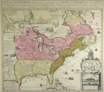
CARTE DE LA NOUVELLE FRANCE, où se voit le cours des Grandes Rivieres de S. LAURENS & de MISSISSIPI Aujour d'hui S. LOUIS/Aux Environs des-quelles se trouvent les ETATS, PAÏS, NATIONS, PEUPLES &c de la FLORIDE, de la LOUÏSIANE, de la VIRGINIE, de la MARIE-LANDE, de la PENSYLVANIE/du NOUVEAU JERSAY, de la NOUVELLE YORCK, de la NOUV. ANGLETERRE, de L'ACADIE, du CANADA, des ESQUIMAUX, des HURONS, des IROQUOIS, des ILINOIS &c. Et de la/Grande Ile de TERRE NEUVE
Johannes Covens
1740
1979.253
Carte particulière des environs de St. Malo et des entrées de la Rivière de Dinan, comme elles paroissent aux plus basses marées
Nicolas de Fer
1690
1980.452
Plan de Port Royale et de ses environs situé dans la Baye de Campeche
Jacques Nicolas Bellin
1754
1979.158
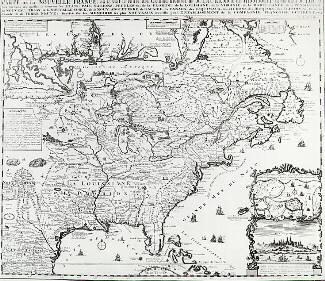
Carte de la Nouvelle France, où se voit le cours des Grandes Rivières de S. Laurens & de Mississipi, aujourd'hui S. Louis. Aux environs des-quelles se trouvent les états, pais, nations, peuples, &c. de la Floride, de la Louisiane, de la Virginie, de la Marie-Lande, de la Pensilvanie, du Nouveau Jersay, de la Nouvelle Yorck, de la Nouv. Angleterre de L'Acadie, du Canada, des Esquimaux, des Hurons, des Iroquois, des Ilinois &c. Et de la Grande Ile de Terre-Neuve:
Henri Abraham Chatelain
1732
1979.506
This project is made possible thanks to the generous support of the Azrieli Foundation and Canadian Heritage.