

Skip to main contentMap - The Isles of Montreal as they have been survey'd by the French Engineers | McCord Museum Online Collections | McCord Museum - Montreal Social History Museum 


Map
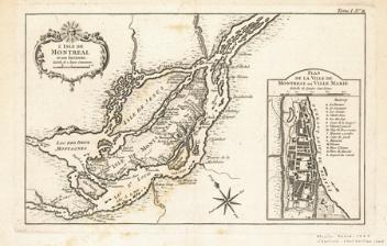
The Isles of Montreal as they have been survey'd by the French Engineers
Cartographer
Jacques Nicolas Bellin
(1703-1772)
Date
1761
Medium / Technique
Ink on paper
Engraving
Engraving
DimensionsHeight: 26.5 cm (10 7/16 in.)
Image width: 33.3 cm (13 1/8 in.)
Width: 36 cm (14 3/16 in.)
Image height: 23.8 cm (9 3/8 in.)
ClassificationTools & Equipment for Science & Technology - Surveying & Navigational T&E - Navigational Equipment
Origin
London, Greater London, England, Europe
Object Number1979.112
DivisionArchives - Maps and Plans
CollectionStewart
Status
Not on viewInformation about the objects in our collection is updated to reflect new research findings. If you have any information to share regarding this object, please email reference.mccord@mccord-stewart.ca.Information about rights and reproductions is available here.
The Isles of Montreal as they have been survey'd by the French Engineers
Jacques Nicolas Bellin
1744-1761
1979.111
The Isles of Montreal as they have been survey'd by the French Engineers
Jacques Nicolas Bellin
1761
1979.110
Carte des prétentions des Anglois dans l'Amérique Septentrionale suivant leurs chartres tant sur les posessions de la France que sur celles de l'Espagne
Jacques Nicolas Bellin
1755-1757
1982.13.3
A map of Royal Island or Cape Breton / The Town and Harbour of Louisbourg on the Island of Cape Breton
Jacques Nicolas Bellin
1758
1979.235
Carte réduite du Golphe de St. Laurent contenant l'Isle de Terre-Neuve et Partie de la Coste des Esquimaux l'Ilse Royale, l'Isle St. Jean et celle d'Anticosti
Jacques Nicolas Bellin
1754
1979.505
Mappe-Monde ou carte générale de la terre sur la quelle est tracée le Voyage de Robinson Crusoé.
Jacques Nicolas Bellin
1740
1979.74
A new chart of the coast of New England, Nova Scotia, New France or Canada with the islands of Newfoundland, Cape Breton, St. John's
Jacques Nicolas Bellin
1763
1980.510
This project is made possible thanks to the generous support of the Azrieli Foundation and Canadian Heritage.