

Skip to main contentPlan - St. Malo | McCord Museum Online Collections | McCord Museum - Montreal Social History Museum 


![Lutetia Parisiorum urbs. [Paris, France]](/internal/media/dispatcher/260863/thumbnail)


![de Haven van St. Thomas [Havre de Saint-Thomas]](/internal/media/dispatcher/260839/thumbnail)


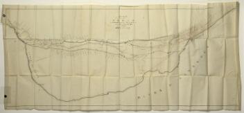
Plan
St. Malo
Inscriptionscartouche : St. Malo, Ville de la Haute Bretagne, Située dans l'Isle S. AAron jointe à la terre ferme par un pont ou chaussée a 48 degr. 40 min. de Latitude et 18 degrez 10 min. de Longitude. Ce n'estoit autrefois qu'une Abbaye lors que l'Evéché de Quidalet y fut transferé l'an 1172. Cette ville est apresent un des plus fameux ports de l'Europe et ses habitans sont estimez des plus hardis sur mer.
Period
18e siècle
Medium / Technique
Ink on paper
Etching?, copper engraving?
Etching?, copper engraving?
DimensionsHeight: 35.6 cm (14 in.)
Image width: 27.8 cm (10 15/16 in.)
Width: 26.3 cm (10 3/8 in.)
Image height: 21.2 cm (8 3/8 in.)
Origin
France, Europe
Object Number1970.2179
DivisionArchives - Maps and Plans
CollectionStewart
Status
Not on viewInformation about the objects in our collection is updated to reflect new research findings. If you have any information to share regarding this object, please email reference.mccord@mccord-stewart.ca.Information about rights and reproductions is available here.
St. Malo Ville de la Haute Bretagne située dans L'isle St. Aaron. Carte particulière des environs de St. Malo et des entrées de la Rivière de Dinan comme elles paroissent aux plus Basses Marées.
Antoine de Fer
1652
1979.293
Carte particulière des environs de St. Malo et des entrées de la Rivière de Dinan, comme elles paroissent aux plus basses marées
Nicolas de Fer
1690
1980.452
Verthoninghe van de Zee Custen van Bretaignen; Soe hem tlandt aldaer noter zee opdoet; Tuschen S: Malo en Rouscou, Doer.
Jan van Doetichum the Elder
1583
1979.512
Plan of the Military & Naval operations under the command of the immortal Wolfe & Vice Admiral Saunders before Quebec
Alfred Hawkins
1841
1979.297
City of Montreal. Parts of St. James, East, Centre, St. Louis and St. Lawrence Wards
Alphonse Rodrigue Pinsoneault
ca. 1907
RB-1494.14
Proposed Plan of the Lachine Canal from the Foot of St. Mary's Current to the Branch Leading to the Port of Montreal
Alexander Gibbs
before 1821
P195/A9.1
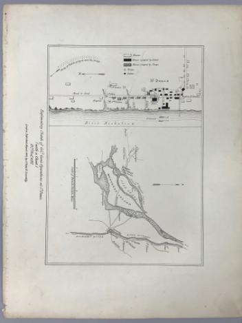
Explanatory Sketch of Colonel Gore's Operations at St Denis (with a Chart) 23rd, November, 1837
Lord Charles Beauclerk
1840
1970.1061
This project is made possible thanks to the generous support of the Azrieli Foundation and Canadian Heritage.