

Skip to main contentMap - A New Chart of the Vast Atlantic Ocean Exhibiting the Seat of War both in Europe and America | McCord Museum 
Online Collections | McCord Museum - Montreal Social History Museum 


Map
A New Chart of the Vast Atlantic Ocean Exhibiting the Seat of War both in Europe and America
Geographer
Emanuel Bowen
(1694-1767)
InscriptionsCartouche, b.g.: A NEW CHART / of the Vast / ATLANTIC OCEAN / Exhibiting / The SEAT of WAR / both in / EUROPE and AMERICA / likewise the Trade Winds & Course of / Sailing from one continent to another / with the banks, shoals and Rocks drawn / according to the latest discoveries and / regulated by astronomical observations; au centre, bas: Publish'd according to Act of Parliament, for the London Magazine 1755; au centre, haut: A Table comparing this chart with Mr. Popple's / great Map of the British Empire in America [...]
Date
1755
Medium / Technique
Ink on paper
Intaglio, hand-coloured
Intaglio, hand-coloured
DimensionsHeight: 32.6 cm (12 13/16 in.)
Image width: 43 cm (16 15/16 in.)
Width: 45.5 cm (17 15/16 in.)
Image height: 30.6 cm (12 1/16 in.)
ClassificationTools & Equipment for Science & Technology - Surveying & Navigational T&E - Navigational Equipment
Origin
London, Greater London, England, Europe
Object Number1970.2181
DivisionArchives - Maps and Plans
CollectionStewart
Status
Not on viewInformation about the objects in our collection is updated to reflect new research findings. If you have any information to share regarding this object, please email reference.mccord@mccord-stewart.ca.Information about rights and reproductions is available here.
Chart of the Atlantic Ocean, with the British, French & Spanish Settlements in North America and the West Indies; as also on the Coast of Africa
Thomas Jefferys
1768
1979.247
Chart of the Atlantic Ocean, with the British, French & Spanish Settlements in North America and the West Indies; as also on the Coast of Africa
Thomas Jefferys
1768
1979.248
A map exhibiting the dark shadow of the moon over England and other parts of Europe, in the five great solar eclipses, of the years 1715, 1724, 1737, 1748 and 1764
Robert Sayer
1794
1992.122
A new chart of the coast of New England, Nova Scotia, New France or Canada with the islands of Newfoundl'd Cape Breton St John & C
Jacques Nicolas Bellin
1763
1979.298
A new chart of the coast of New England, Nova Scotia, New France or Canada with the islands of Newfoundland, Cape Breton, St. John's
Jacques Nicolas Bellin
1763
1980.510
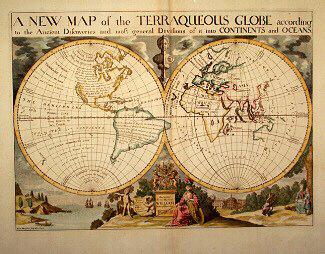
A NEW MAP of the TERRAQUEOUS GLOBE according to the Ancient Discoveries and most general Divisions of it into CONTINENTS and OCEANS
Edward Wells
1700-1738
1979.194
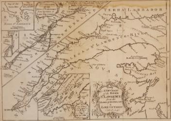
A New Chart of the River St. Lawrence from the Island of Anticosti to Lake Ontario
Thomas Kitchin
1759
1979.101
This project is made possible thanks to the generous support of the Azrieli Foundation and Canadian Heritage.