

Skip to main contentMap - The Province of Maine | McCord Museum Online Collections | McCord Museum - Montreal Social History Museum 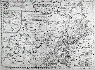

![Carte de la Province de Poitou [...] des Provinces voisines](/internal/media/dispatcher/261414/thumbnail)


![Greneland [Groenland]](/internal/media/dispatcher/260858/thumbnail)

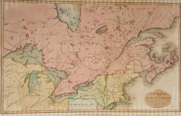
Map
The Province of Maine
Artist
Samuel Lewis
(1753-54 - 1822)
Engraver
William Barker
(actif 1795 - 1803)
InscriptionsThe Province of Maine from the best authorities. By Samuel Lewis, 1794. W. Barker sculp.
Date
1795
Medium / Technique
Ink on paper
Intaglio
Intaglio
DimensionsHeight: 41.5 cm (16 5/16 in.)
Image width: 24.3 cm (9 9/16 in.)
Width: 33.4 cm (13 1/8 in.)
Image height: 35.9 cm (14 1/8 in.)
ClassificationTools & Equipment for Science & Technology - Surveying & Navigational T&E - Navigational Equipment
Origin
London, Greater London, England, Europe
Object Number1970.1904
DivisionArchives - Maps and Plans
CollectionStewart
Information about the objects in our collection is updated to reflect new research findings. If you have any information to share regarding this object, please email reference.mccord@mccord-stewart.ca.Information about rights and reproductions is available here.
The Provinces of New York and New Jersey; with part of Pensilvania, and the Governments of Trois Rivieres, and Montreal
Major Samuel Holland
1775
1981.783.1
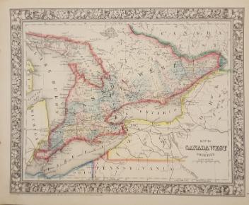
Principal seats of the war of 1812-13-14 To accompany Williard's History of the United States.
Samuel Maverick
1982.110.2
This project is made possible thanks to the generous support of the Azrieli Foundation and Canadian Heritage.