Collections Menu

Archives

Close
Refine Results
Object
Date
to
People
Classification
City
Division
Sort:
Filters
25 to 48 of 4,086
Online Collections | McCord Museum - Montreal Social History Museum
Plan du Pélican
François Cordeau
1960
1970.1965
L'isle de Montréal et ses environs
Jacques Nicolas Bellin
1764
1970.2002
Les cotes de France
Les cotes de France
Christian Friedrich von der Heyden
1758
1970.2003
Plan of the Town & Fortifications of Montreal or Ville Marie in Canada
1760
1970.2004
Plan de la ville de Montréal en Canada
Pierre Moullart-Sanson
1878
1970.2006
Montréal
Montréal
John Gibson
1760
1970.2007
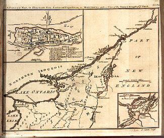
A New Map of the Province of Quebec, according to the Royal Proclamation of the 7th of October 1763
Capt. Jonathan Carver
1776
1970.2008.1-2
A Map of the Several Dispositions of the English Fleet & Army on the River St. Laurence to the taking of Quebec
1760
1970.2067
A plan of the Town and Fort of Carillon at Ticonderoga; with the Attack made by the British Army.
Thomas Jefferys
1759
1970.2070
A Prospective View of the Battle fought near Lake George, on the 8th of Sep.r 1755
Samuel Blodget
1756
1970.2071
Attaques du Fort William-Henri en Amérique par les troupes française aux ordres du Marquis de Montcalm. Prise de ce fort le 7 août 1757.
Laurids de Therbu
1793
1970.2072
Attaques des Forts de Chouaguen en Amérique pris par les Français commandés par le Marquis de Montcalm. Le 14 Août 1756.
Laurids de Therbu
1792
1970.2073
Le Plan de Louisbourg dans L'Isle royale au Canada. 1757 [...]
Laurids de Therbu
1793
1970.2074
Map of the Nile Valley
1970.2087
Plan of  York Harbour
Plan of York Harbour
1815
1970.2117
Plan of Oswego
Plan of Oswego
Gaspard Chaussegros de Léry
1727
1970.2118
Nova Scotia and Newfoundland
Alexander Fussell
1851
1970.2119.1-2
British America
British America
Henry Warren
1851
1970.2120
City of Montréal
City of Montréal
J. & C. Walker
1830
1970.2121
A Map of the Country between Crown Point and Fort Edward
1755 ?
1970.2122
Plan of Montreal with a map of the islands & adjoining Country.
John Melish
1813
1970.2123
A Plan of the City of Quebec
1798
1970.2125
Partie de la carte du Capitaine Cluny auteur d'un ouvrage anglois intitulé American traveller publié à Londre en 1769.
Didier Robert de Vaugondy
1777
1970.2127
Nouvelle carte de la province de Quebec
Capt. Jonathan Carver
1777
1970.2128

This project is made possible thanks to the generous support of the Azrieli Foundation and Canadian Heritage.