

Skip to main contentCarte géographique - The Province of Maine | Musée McCord Collections en ligne | Musée McCord - Musée d’histoire sociale de Montréal 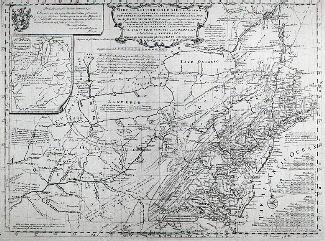

![Carte de la Province de Poitou [...] des Provinces voisines](/internal/media/dispatcher/261414/thumbnail)


![Greneland [Groenland]](/internal/media/dispatcher/260858/thumbnail)

Carte géographique
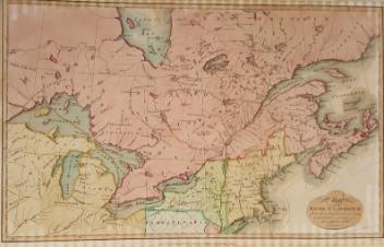
The Province of Maine
Artiste
Samuel Lewis
(1753-54 - 1822)
Graveur
William Barker
(actif 1795 - 1803)
InscriptionsThe Province of Maine from the best authorities. By Samuel Lewis, 1794. W. Barker sculp.
Date
1795
Médium / Technique
Encre sur papier
Taille douce
Taille douce
DimensionsHauteur : 41,5 cm (16 5/16 po)
Largeur de l'image : 24,3 cm (9 9/16 po)
Largeur : 33,4 cm (13 1/8 po)
Hauteur de l'image : 35,9 cm (14 1/8 po)
Origin
Londres, Grand Londres, Angleterre, Europe
Numéro d'accession1970.1904
DivisionArchives - Cartes et plans
CollectionStewart
L’information sur les objets de nos collections est mise à jour afin de refléter les résultats de nouvelles recherches. Si vous avez des renseignements au sujet de cet objet à nous communiquer, veuillez faire parvenir un courriel à reference.mccord@mccord-stewart.ca.L’information au sujet des droits d’auteur et des reproductions se trouve ici.
The Provinces of New York and New Jersey; with part of Pensilvania, and the Governments of Trois Rivieres, and Montreal
Major Samuel Holland
1775
1981.783.1
Carte de la Province de Poitou [...] des Provinces voisines
Jean Crépy
1767
1983.730
A chart of the Sea coast from England to the Streights
Samuel Thornton
1706
1979.290
Principal seats of the war of 1812-13-14 To accompany Williard's History of the United States.
Samuel Maverick
1982.110.2
Ce projet est rendu possible grâce au généreux soutien de la Fondation Azrieli et de Patrimoine canadien.