

Skip to main contentPlan - City of Montreal. Parts of St. James, East, Centre, St. Louis and St. Lawrence Wards | Musée McCord 
Collections en ligne | Musée McCord - Musée d’histoire sociale de Montréal 

![The River St Laurence. [Montreal]](/internal/media/dispatcher/258377/thumbnail)


![de Haven van St. Thomas [Havre de Saint-Thomas]](/internal/media/dispatcher/260839/thumbnail)


Plan
City of Montreal. Parts of St. James, East, Centre, St. Louis and St. Lawrence Wards
Compilateur
Alphonse Rodrigue Pinsoneault
Date
1906
Dimensions46,0 x 73,0 cm
Numéro d'accessionRB-1494.14
DivisionArchives - Cartes et plans
CollectionMcCord
Status
Non exposéL’information sur les objets de nos collections est mise à jour afin de refléter les résultats de nouvelles recherches. Si vous avez des renseignements au sujet de cet objet à nous communiquer, veuillez faire parvenir un courriel à reference.mccord@mccord-stewart.ca.L’information au sujet des droits d’auteur et des reproductions se trouve ici.
Looking towards centre section of the city from St. James Street, Montreal, QC, ca. 1935
Harry Sutcliffe
Vers 1935
M2011.64.2.4.76
St. Malo Ville de la Haute Bretagne située dans L'isle St. Aaron. Carte particulière des environs de St. Malo et des entrées de la Rivière de Dinan comme elles paroissent aux plus Basses Marées.
Antoine de Fer
1652
1979.293
America with those known parts in that unknowne worlde both people and manner of buildings
Abraham Goos
1626
1982.8.1
A map exhibiting the dark shadow of the moon over England and other parts of Europe, in the five great solar eclipses, of the years 1715, 1724, 1737, 1748 and 1764
Robert Sayer
1794
1992.122
A New map of the North Parts of America claimed by France under ye names of Louisiana, Mississipi, Canada and New France with ye adjoyning territories of England and Spain
Herman Moll
1720
1979.250
A Map of the Several Dispositions of the English Fleet & Army on the River St. Laurence to the taking of Quebec
1760
1970.2067
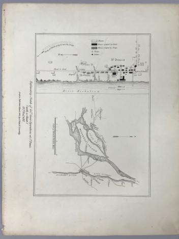
Explanatory Sketch of Colonel Gore's Operations at St Denis (with a Chart) 23rd, November, 1837
Lord Charles Beauclerk
1840
1970.1061
Ce projet est rendu possible grâce au généreux soutien de la Fondation Azrieli et de Patrimoine canadien.