

Skip to main contentIntaglio print - A New and accurat map of the world | McCord Museum 
Online Collections | McCord Museum - Montreal Social History Museum 


Intaglio print
A New and accurat map of the world
Artist
Pieter Van den Keere
(1571 - 1646)
Cartographer
John Speed
(1552-1629)
Inscriptionshaut: A NEW AND ACCURAT MAP OF THE WORLD; bas: Drawne according to Ye truest Descriptions latest Discoveries Pe Kaerius / coelavit 1646
Date
1646
Medium / Technique
Ink on paper
Intaglio, hand-coloured
Intaglio, hand-coloured
DimensionsHeight: 9.8 cm (3 7/8 in.)
Image width: 12 cm (4 3/4 in.)
Width: 15.5 cm (6 1/8 in.)
Image height: 8.3 cm (3 1/4 in.)
Origin
London, Greater London, England, Europe
Object Number1979.71
DivisionArchives - Maps and Plans
CollectionStewart
Status
Not on viewInformation about the objects in our collection is updated to reflect new research findings. If you have any information to share regarding this object, please email reference.mccord@mccord-stewart.ca.
Information about rights and reproductions is available here.
Canada ou Nouvelle France, suivant les nouvelles observations de Mess'rs. de l'Académie Royale des Sciences
Pieter van der Aa
1700
1980.84
Land en Volk-Ontdekking in't Noorder gedeelte van America door P. Marquette en Joliet; gedaan in't Jaar 1673
Pieter van der Aa
1707
1978.507
Angliae orae maritimae inter Plemoutham et Portlandiam simul et praecipuoru portinum, vera effigies et delineatio
Jan van Doetichum the Elder
1603
1983.693
Canalis celebris vel navigationis a Bristo...
Jan van Doetichum the Elder
1603
1980.528
Carte nouvelle de la Mer Méditerranée où sont exactement remarqués tous les ports, golfes, rochers, bancs de sable &c. à l'usage des Armées du Roy
Pieter Mortier
1710
1979.299
Mer du Sud ou Pacifique contenant l'isle de Californie, les Costes de Mexique, du Perou, Chili et Destroit de Magellanique, etc. dressée sur les relations les plus nouvelles
Pieter Mortier
1700
1979.526
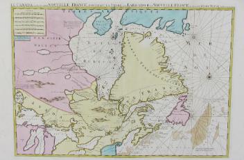
Le Canada ou Partie de la Nouvelle France contenant la terre de Labrador, la Nouvelle France, les isles de Terre Neuve, de Nostre Dame
Pieter Mortier
1700
1979.223
A Map of Glamorganshire; The Road from London to St. Davids
Emanuel Bowen
1720
1979.149
A new and correct map of the world projected upon the plane of The Horizon laid down from the newest discoveries and most exact observations
Charles Price
1714
1979.196
This project is made possible thanks to the generous support of the Azrieli Foundation and Canadian Heritage.