

Skip to main contentMap - Montreal Harbour as at 1st May, 1940 | McCord Museum Online Collections | McCord Museum - Montreal Social History Museum 


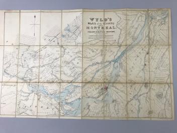


Image Not Availablefor Montreal Harbour as at 1st May, 1940
Map
Montreal Harbour as at 1st May, 1940
InscriptionsMontreal Harbour as at 1st May, 1940. (National Harbours Board). R.O. Campnety Chairman... Boundaries of the Harbour of Montreal... 1936... Season of Navigation... Depth of Water...
Date
1940
Medium / Technique
Ink on paper
Lithography
Lithography
DimensionsHeight: 34.5 cm (13 9/16 in.)
Image width: 165 cm (64 15/16 in.)
Width: 168.4 cm (66 5/16 in.)
Image height: 31.2 cm (12 5/16 in.)
ClassificationTools & Equipment for Science & Technology - Surveying & Navigational T&E - Navigational Equipment
Origin
Montreal, Montreal, Quebec, Canada, North America
Object Number1970.3088
DivisionArchives - Maps and Plans
CollectionStewart
Status
Not on viewInformation about the objects in our collection is updated to reflect new research findings. If you have any information to share regarding this object, please email reference.mccord@mccord-stewart.ca.Information about rights and reproductions is available here.
A map of Royal Island or Cape Breton / The Town and Harbour of Louisbourg on the Island of Cape Breton
Jacques Nicolas Bellin
1758
1979.235
Wyld's sketch of the Country around Montreal shewing the Villages and Military Positions
James Wyld
1837
1970.1834
This project is made possible thanks to the generous support of the Azrieli Foundation and Canadian Heritage.