Collections Menu
Cartoon - Political Map of Europe. | McCord Museum
La carte politique de l'Europe
View PDF
La carte politique de l'Europe

Cartoon

Political Map of Europe.
Artist (1917-2007)
SignatureL. r. within image, JOHN COLLINS
Date About 1955
Medium / Technique Ink, graphite, watercolour and opaque white pigment on paper
Dimensions36.9 x 29.3 cm
Origin Montreal, Quebec, Canada
Object NumberM965.199.730
CollectionMcCord
CreditGift of John Collins - The Gazette
Status
Not on view

Information about the objects in our collection is updated to reflect new research findings. If you have any information to share regarding this object, please email reference.mccord@mccord-stewart.ca.

Information about rights and reproductions is available here.

Online Collections | McCord Museum - Montreal Social History Museum
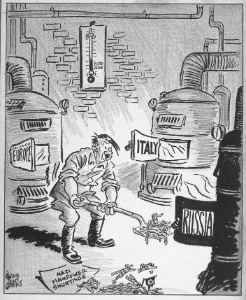
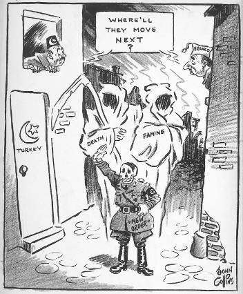
Political Map of Asia.
John Collins
About 1955
M965.199.723
Soviet Map of Europe.
John Collins
About 1957
M965.199.6247
Europe's Carol.
Europe's Carol.
John Collins
About 1952
M965.199.5480
Europe's Button.
Europe's Button.
John Collins
About 1952
M965.199.5497
New Wayside Cross in Eastern Europe.
John Collins
About 1949
M965.199.8369
"Feed the Hungry Mouths of Europe".
John Collins
1941/04/02
M965.199.3076
Europe's Moving Problem.
John Collins
1941/05/02
M965.199.3102
March in Europe.
March in Europe.
John Collins
1940/03/01
M965.199.1732
Moving Day in Europe.
John Collins
1940/05/01
M965.199.1782
A Winter Sport Note from Europe.
John Collins
About 1939
M965.199.4243
Fuel Problem in Fortress Europe.
John Collins
1943/12/27
M965.199.2269
Spring in Eastern Europe.
John Collins
About 1968
M965.199.6530

This project is made possible thanks to the generous support of the Azrieli Foundation and Canadian Heritage.